

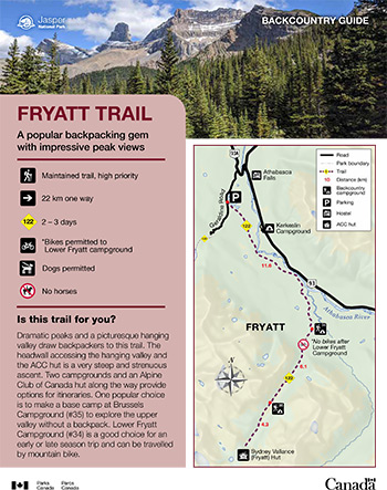
A popular backpacking gem with impressive peak views
Fryatt Trail
Jasper National Park
 Fryatt Trail Backcountry Guide (PDF, 2.7 MB)
Dramatic peaks and a picturesque hanging valley draw backpackers to this trail. The headwall accessing the hanging valley and the ACC hut is a very steep and strenuous ascent. Two campgrounds and an Alpine Club of Canada hut along the way provide options for itineraries. One popular choice is to make a base camp at Brussels Campground (#35) to explore the upper valley without a backpack. Lower Fryatt Campground (#34) is a good choice for an early or late season trip and can be travelled by mountain bike.
Planning considerations
- Maintained trail: high priority
- 22 km one way
- Trail #122: 2-3 days
- Bikes permitted to Lower Fryatt campground
- Dogs permitted
- No horses
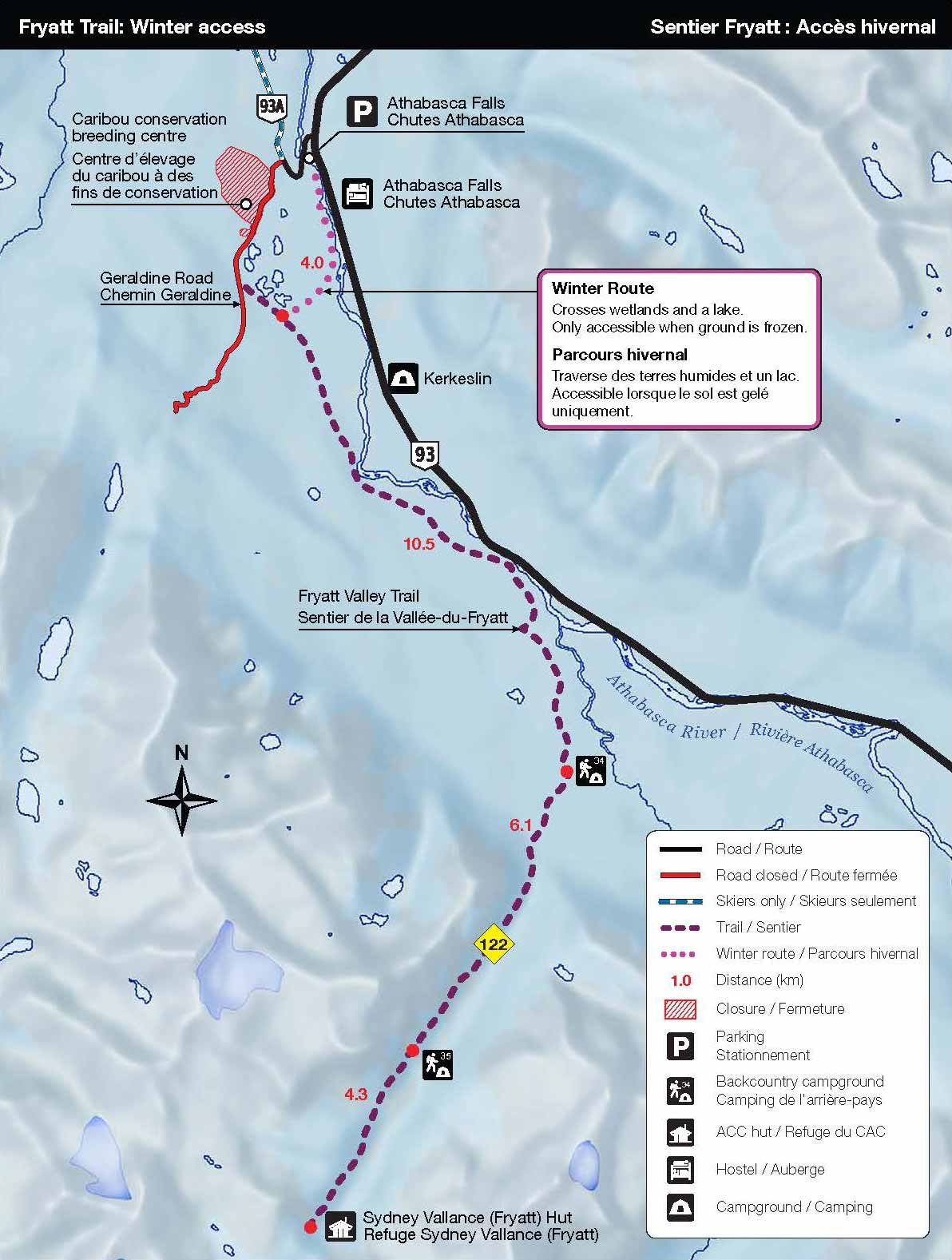
From June 9 to September 30: Geraldine Road is open to public traffic subject to the following restrictions:
- During working hours (typically 07:00 to 19:00), travel on Geraldine Road by vehicle only. Drive with care. Follow traffic control measures and all posted speed limits and warnings. Expect delays of up to 15 minutes. Work schedules are subject to change without notice.
- During non-working hours, the road is open to all users.
From October 1 to June 8: Geraldine Road is closed to traffic for the winter season.
Public access on the first 1.44 km of Geraldine Road is restricted to ensure safety during construction. Use the winter route from Athabasca Falls for access to the Fryatt Valley.
The details
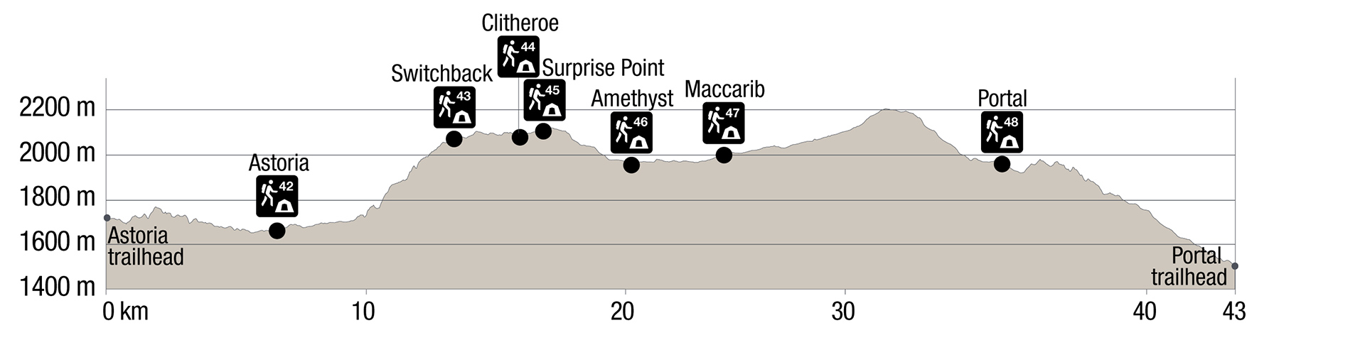
The first 12 km of this trail to Lower Fryatt Campground (#34) is along an old fire road. Beyond Lower Fryatt Campground, the trail climbs steadily through the forest for another 4 km before reaching an open U-shaped valley. The views from Brussels Campground (#35) are stunning. Two kilometres past Brussels, the trail follows the shore of Fryatt Lake to the base of the headwall, at 21.1 km. From here, ascend the headwall, a steep 200 m climb, to the upper valley and the Sydney Vallance Hut (Alpine Club of Canada).
The Alpine Club of Canada (ACC) manages the beautiful Sydney Vallance hut (capacity 12) at the top of the headwall at km 22. Visit alpineclubofcanada.ca for information on booking the hut.
- The headwall is very steep and can be dangerous if you veer off the trail. Follow the yellow markers and backtrack if you lose the trail.
- The Headwall Campground has been removed as it was in an avalanche path. Camping is no longer permitted here.
- Experienced boaters with proper equipment can cross the Athabasca River just south of the Goats and Glaciers Viewpoint on the Icefields Parkway and cut 7 km from the hike. Note that the Athabasca River is fast and very cold (4-6°C). The crossing requires experience in swift water paddling, especially when water levels are high. The crossing is not recommended for novice paddlers.
- If travelling during winter months, be sure to check avalanche conditions, have the necessary knowledge, experience and avalanche safety gear. Consider hiring a guide.
- Porcupines may be present near campgrounds. They can be attracted to your equipment or anything with a salt content.
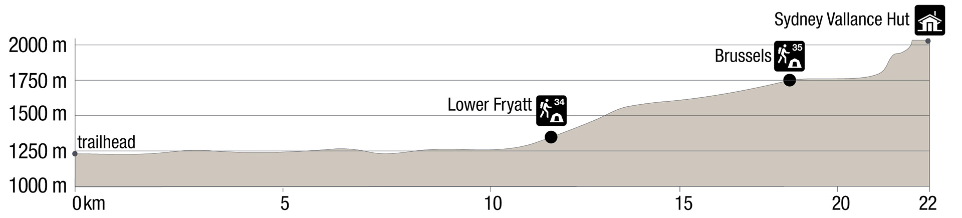
Elevation profile
Text version
- The trailhead is at 1220 m.
- The trail is mainly flat for the 11.6 km to Lower Fryatt Campground (1280 m) except for an ascent just before the campground.
- There is a steady climb for 6.1 km to Brussels Campground (1715 m).
- No significant elevation changes for 3.4 km then a very steep climb for 800 m to just before the Sydney Vallance Hut.
- The trails levels for the 100m to the Hut.
Campground information
| Campground | Elevation (m) | Description | # of sites | Toilet type | Food storage | UTM |
|---|---|---|---|---|---|---|
| Lower Fryatt #34 |
1280 m | This campground is located next to Fryatt Creek and a bridge crossing into the valley proper between mounts Christie and Fryatt. Bike access ends here. | 6 | Throne | Lockers | 11U 444505 5825366 |
| Brussels #35 |
1715 m | A somewhat forested campground, which still has great views of the surrounding mountains. | 8 | Barrel | Lockers | 11U 441868 5820614 |
How to get there

From Jasper: 31 km
- Take the Icefields Parkway (Highway 93) towards Lake Louise.
- At Athabasca Falls (30 km south of Jasper) turn right onto Wabasso Road (93A). Continue for 1 km.
- Turn left onto unpaved Geraldine Road and continue for 2 km
From Banff: 255 km
- Follow the Icefields Parkway north towards Jasper.
- Turn left at the junction for Highway 93A and Athabasca Falls, 200 km north of Lake Louise.
- Turn left onto unpaved Geraldine Road and continue for 2 km
Note: Geraldine Road is a seasonal access road that is open from mid-June to late September. Check 511.alberta.ca to confirm if the road is open.
This is a rough gravel road. High-clearance vehicles are recommended. No trailers or RVs are permitted.
Are you prepared?
Safety is your responsibility
Refer to the Jasper National Park Backcountry Planning Guide:
- descriptions of trail types and campground facilities;
- equipment checklists;
- responsible camping practices;
- safety information.
Before heading out, check trail, weather and road conditions at: parks.canada.ca/jaspertrails.
Maps
| NTS | National Geographic | Gem Trek |
|---|---|---|
| Athabasca Falls 83C/12 | Jasper South | Jasper and Maligne Lake |
Permits
A backcountry camping permit is mandatory for all overnight trips and can be obtained online at reservation.pc.gc.ca or by calling 1-877-737-3783.
- Date modified :