

Inuit traditional knowledge
Wrecks of HMS Erebus and HMS Terror National Historic Site
Inuit Qaujimajatuqangit at its best
Inuit traditional knowledge outlined the search area. The archaeological technology and methods employed underwater and on land gave us the tools needed to make a thorough scientific search, and aided with the final discovery of the wrecks.
“..without traditional knowledge the search would have been wholly impractical...”
Inuit oral histories
Traditional knowledge passed down through generations has come full circle almost 170 years after Inuit first observed the disastrous and tragic consequences of the Franklin expedition. Learn more about how this knowledge led to the discovery of the wrecks.
Inuit oral histories in the 1850s
In 1850, Royal Navy searchers discovered that Franklin had wintered at Beechey Island but found no information as to where he headed next.
Four years later, in 1854, Hudson’s Bay Company (HBC) searcher Dr. John Rae learned from Inuit at Pelly Bay and Repulse Bay, Nunavut, that around 1848 some 40 white men had been seen on the western shore of King William Island heading southwards, apparently after their ships had become trapped by ice.
Inuit reported that later the bodies of 30 or so men were found farther south near the mouth of the Back River on the mainland coast. Rae carefully recorded these stories and bartered for Franklin Expedition objects that Inuit had collected.

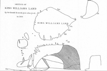
Click to enlarge
Map of King William Island

An expedition, led by Captain Francis Leopold McClintock, found a note left by the Franklin expedition in a cairn on the northwest corner of King William Island. This document explained that the ships had become beset in ice nearby in 1846, that Franklin died in June 1847, and that in April 1848 the surviving 105 crew members had deserted the ships and were presumably making an overland retreat to the nearest Hudson’s Bay Company post, hundreds of miles to the south.
McClintock found many traces of this retreat, including the bodies of crew members who died during the trek. He learned from meetings with Inuit that one of the ships had later been wrecked on the west coast of King William Island, and that the other had been wrecked in a place called “Ook-joo-lik” (Ugjulik).
Inuit oral histories in the 1860s and 1870s
©The Thomas Fisher Rare Book Library, University of Toronto
Charles Francis Hall, an American journalist, was next to take up the search and seek out more evidence. Spending years in the Arctic, travelling and living among Inuit, he gathered invaluable Inuit oral histories.
Importantly, interpreters Taqulittuq and Ipiivik were part of his team. In 1869, he learned that the Ugjulik wreck was located off the western shore of the Adelaide Peninsula; Ugjulik (spelled variously) refers to a seal hunting ground, the word meaning as “there are bearded seals there.”
Although Hall did not travel there himself, he collected specific information from Inuit informants that the wreck was located northeast of O’Reilly Island. One informant, an Inuk named Inukpujijuk (In-nook-poo-zhe-jook), pointed out the location of the wreck on an Admiralty chart Hall used, and even drew his own map of the wreck location.
Hall learned that an Inuk had found the ship afloat in the ice one spring, that there was evidence of the crew members having left the ship, and that Inuit had later gone on board and salvaged as many items as they could before it sank. They had even found the body of a crew member inside.
The last major nineteenth-century contribution to the story came from an 1878-1880 expedition led by Lieutenant Frederick Schwatka, an American cavalry officer. With the aid of interpreters, including Ipiivik, he recorded informative oral histories about the expedition, and importantly for us, information about the Ugjulik wreck. He was told that it was sunk off what he deduced was Grant Point, at the northwest tip of the Adelaide Peninsula.
Inuit oral histories and the modern search
Although interest in the fate of the Franklin Expedition and its ships did not abate, it would be over 80 years before the wreck search was resumed. Beginning in the 1960s, researchers had begun to search for the Ugjulik wreck, searching along the shoreline and diving in the frigid waters.
The quest for the wreck was taken up by Canadian researcher and explorer David C. Woodman. He published an important book in 1992 called Unravelling the Franklin Mystery: Inuit Testimony. This exhaustive study was a reappraisal and compilation of the Inuit evidence and is an important reference work.
Woodman had spent years beginning in the 1990s searching for the wreck firsthand, often using search methods deployed from the ice in spring time, and drawing on partners that included local Inuit team members. Unfortunately, his repeated searches did not result in a wreck discovery.
Traditional knowledge meets contemporary search tools
It was in the early 1990s that Parks Canada’s Underwater Archaeology Team became involved in the search for the shipwrecks.
In 1997, the team took part in a major search for the Ugjulik wreck that involved a range of government and non-government partners, including David Woodman and Inuit researcher the late Louie Kamookak, who resides in Gjoa Haven, the community closest to the proposed search area.
Following this unsuccessful search, Parks Canada worked closely with Kamookak, who shared his traditional knowledge about regional place names and the Franklin expedition that he had gathered from elders.
“From the outset, the objective was to use both Inuit oral history and Canada’s best technology to search for the shipwrecks.”
The initial team was made up of Inuit Knowledge Holders, including the late Louie Kamookak, as well as members of Parks Canada, the Canadian Coast Guard, the Canadian Hydrographic Service, and importantly the Government of Nunavut.
Parks Canada took the lead in the shipwreck search while Government of Nunavut archaeologists, under the direction of Dr. Douglas Stenton, carried out parallel land-based archaeological surveys. A key component of this work was to search former Inuit habitation sites, for artefacts from the ship or shipwreck.
Reliance on Inuit knowledge has been a constant. Parks Canada and the Government of Nunavut regularly consulted with Kamookak and other residents at Gjoa Haven and Cambridge Bay.
The final discovery
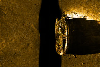
The team completed six years of meticulous side-scan sonar searching for the Ugjulik wreck, and despite week after week of laborious work to cover as much seafloor as possible in the search area, they never gave up on the belief that Inuit oral histories were accurate.
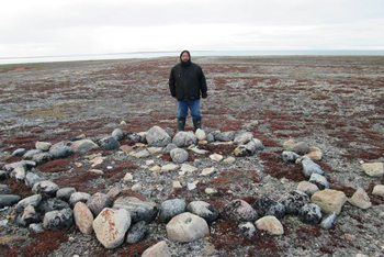
The well-practiced methods honed over the years paid off in 2014. On an island in the search area, Government of Nunavut team members found two artefacts from the Ugjulik wreck that had been cached by some unknown Inuk on an island.
Parks Canada shifted its search area based on this discovery and the wreck of HMS Erebus was located soon after, northeast of O’Reilly Island, near to where Inukpujijuk told Hall it had sunk.
In 2016, the wreck of HMS Terror was discovered in Terror Bay, west of Gjoa Haven along the King William Island Coast. Parks Canada divers confirmed the wreck rests in about 24 metres of water, which has contributed to the vessel’s well-preserved condition.
Related links
- Date modified :