
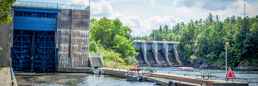
Lock 43 - Swift Rapids
Trent-Severn Waterway National Historic Site
Lock 43 is isolated with a sense of wilderness and therefore not practical to drive to by road. This is the deepest single chambered lock on the Waterway. An impressive ground surrounded by lush natural vegetation makes a quiet stop for boater camping and picnicking for the self-contained boater. It is a pack-in pack-out station.
Getting here
- Address: 19SR 409 Unit 1, Honey Harbour, Ontario
- Nautical chart: #2029 (more on Nautical charts)
- Kilometer marker: 361.2 km (mile 224.5)
- GPS: 44°51'28.2"N 79°32'24.6"W
Hours of Operation
Contact:
- Phone number: (705) 756 - 8177
- Email address: trentsevern@pc.gc.ca
Navigational data
- Lock length: 36.6 m (120 ft)
- Lock width: 9.7 m (32 ft)
- Average lift: 14.3 m (47 ft)
- Max. mooring period: 2 nights
Facilities and services
- Overnight mooring
- Shore power
- Camping
- Paddle steps
- Washrooms
- Potable water
- Picnic area
- Visitor information
History
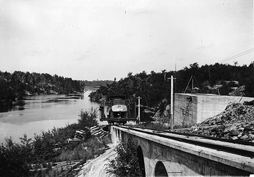
Constructed: 1914-1920
As part of the Severn Division, work on the lock, dam and powerhouse commenced in 1914 but was suspended in 1917 due to wartime shortages. A marine railway was built as a “temporary” measure but remained in place until the present lock was built in 1965. At 47 feet (14.3 metres), this lock has the highest lift on the waterway and is a pack-in, pack-out location.
Tourism information
- Southeast Georgian Bay Chamber of Commerce
Phone number: (705) 756-4863
- Simcoe County - Huronia Tourism Association
Phone number: (705) 726-9300 ext 220 or 1-800-487-6642
- Muskoka Tourism
Phone number: 1-800-267-9700
Google Street View
Related links
- Lock 1 - Trenton
- Lock 2 - Sydney
- Lock 3 - Glen Miller
- Lock 4 - Batawa
- Lock 5 - Trent
- Lock 6 - Frankford
- Lock 7 - Glen Ross
- Lock 8 - Percy Reach
- Lock 9 - Meyers
- Lock 10 - Hagues Reach
- Lock 11-12 - Ranney Falls
- Lock 13 - Campbellford
- Lock 14 - Crowe Bay
- Lock 15 - Healey Falls
- Lock 16 / 17 - Healey Falls Flight Lock
- Lock 18 - Hastings
- Lock 19 - Scotts Mills
- Lock 20 - Ashburnham
- Lock 21 - Peterborough Lift Lock
- Lock 22 - Nassau Mills
- Lock 23 - Otonabee
- Lock 24 - Douro
- Lock 25 - Sawer Creek
- Lock 26 - Lakefield
- Lock 27 - Young's Point
- Lock 28 - Burleigh Falls
- Lock 30 - Lovesick
- Lock 31 - Buckhorn
- Lock 32 - Bobcaygeon
- Lock 33 - Lindsay
- Lock 34 - Fenelon Falls
- Lock 35 - Rosedale
- Lock 36 - Kirkfield
- Lock 37 - Bolsover
- Lock 38 - Talbot
- Lock 39 - Portage
- Lock 40 - Thorah
- Lock 41 - Gamebridge
- Lock 42 - Couchiching
- Lock 44 - Big Chute Marine Railway
- Lock 45 - Port Severn
- Date modified :