
Landscape of Grand Pré
Nova Scotia
Date of Inscription: 2012
The Landscape of Grand Pré tells a remarkable story about human interaction with the environment and about how the connection between people and place can define a collective identity.
Justification of outstanding universal value
The Landscape of Grand Pré was designated as a World Heritage site by UNESCO’s World Heritage Committee under the following criteria:
Criterion (v): The cultural landscape of Grand Pré bears exceptional testimony to a traditional farming settlement created in the 17th century by the Acadians in a coastal zone with tides that are among the highest in the world. The polderisation used traditional techniques of dykes, aboiteaux and a drainage network, as well as a community-based management system still in use today. The resultant rich alluvial soil enabled continuous and sustainable agricultural development.
Criterion (vi): Grand Pré is the iconic place of remembrance of the Acadian diaspora, dispersed by the Grand Dérangement, in the second half of the 18th century. Its polder landscape and archaeological remains are testimony to the values of a culture of pioneers able to create their own territory, whilst living in harmony with the native Mi’kmaq people. Its memorial constructions form the centre of the symbolic re-appropriation of the land of their origins by the Acadians, in the 20th century, in a spirit of peace and cultural sharing with the English-speaking community.
Full description
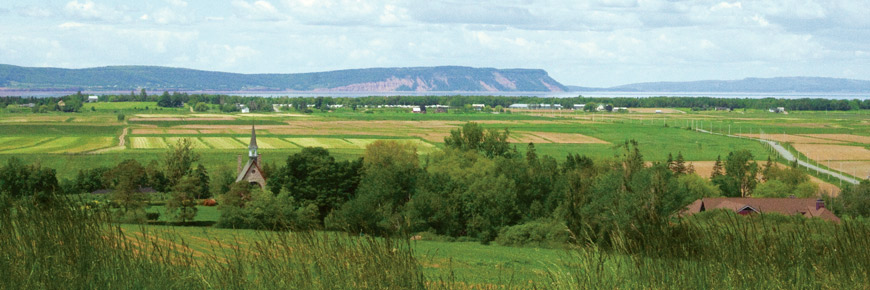
Situated on Nova Scotia’s southern Minas Basin, an inlet of the Bay Fundy, the Landscape of Grand Pré is subjected to the most extreme tides in the world; the tidal range averages 11.6 metres. It was under these conditions three centuries ago that French (Acadian) settlers set about transforming the harsh coastal environment of salt marsh into fertile farmland. The agricultural landscape they claimed from the sea is considered an exceptional example of adaptation by European settlers to the conditions of the North American Atlantic coast.
Starting in the late 17th century – an era which predates the introduction of engineered drainage systems – the Acadian settlers applied an inventive and ingenious system of earthen dykes, ditches and aboiteaux, or wooden sluices, to hold back the formidable tides. They also began a tradition of collective management that was community-based. Today, the agricultural landscape is still protected and drained by the same system, still exhibits distinctive field patterns, and is still managed through the same community approach. Enduring as one of the most intact agricultural polders in the world, it is a testimony to the original Acadian settlers as well as to the New England Planters and the present day farmers who subsequently further developed and maintained the system.
As an important Acadian settlement from 1682 to 1755, Grand Pré is not only directly associated with the emergence of their new identity in their new land, but also with their tragic, forced removal from it. The Deportation of Acadians, known as the Grand Dérangement, started in 1755. As their single most important lieu de mémoire, the Landscape of Grand Pré is an evocative example of a homeland symbolically and peacefully reclaimed by a diaspora that has triumphed over hardships. Here, Acadians celebrate their common heritage and reaffirm their collective identity. They are proud to share the site with the world as a symbol of perseverance and hope.
More Information
Parks Canada:
Grand Pré National Historic Site of Canada
Conservation Treatment of the Evangeline Statue
Historic Sites and Monuments Board of Canada
World Heritage Centre:
World Heritage - Landscape of Grand Pré
Landscape of Grand Pré
Related links
- Anticosti, Quebec
- Tr’ondëk-Klondike, Yukon
- Writing-on-Stone / Áísínai’pi
- L’Anse aux Meadows National Historic Site
- Nahanni National Park Reserve
- Dinosaur Provincial Park
- Kluane / Wrangell-St.Elias / Glacier Bay /...
- Head-Smashed-In Buffalo Jump
- SG̱ang Gwaay
- Wood Buffalo National Park
- Canadian Rocky Mountain Parks
- Historic District of Old Québec
- Gros Morne National Park
- Old Town Lunenburg
- Waterton-Glacier International Peace Park
- Miguasha National Park
- Rideau Canal
- Joggins Fossil Cliffs
- Red Bay Basque Whaling Station
- Mistaken Point
- Pimachiowin Aki
- Date modified :