
Buxton Settlement National Historic Site
© Parks Canada
The Buxton Settlement was designated a national historic site in 1999.
Commemorative plaque: 7th Concession, Dillon and Drake Roads, Buxton Settlement, Buxton, Ontario
From the shores of Lake Erie to the seventh concession, from Dillon Road on the east to Drake Road on the west, Buxton's ordered fields are dotted with churches and homes from the epic experience of the Underground Railroad. In 1849, Reverend William King arrived with fifteen former slaves at a 9,000-acre tract of swampy, forested land. More refugees followed, buying and clearing 50-acre homesteads, establishing industries, churches and schools. The settlers created the regular pattern of roads and drainage ditches seen today, transforming the landscape into the prosperous Elgin Settlement, as it was then called, where neat cottages spoke of industry and thrift, and children received a classical education. Buxton lives on today through descendants of these determined immigrants who carved out a free life for themselves and their families on the tranquil plains of southwestern Ontario.
This plaque text describing the historical significance of the subject was approved by the Historic Sites and Monuments Board of Canada in 1999.
Description of historic place
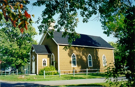
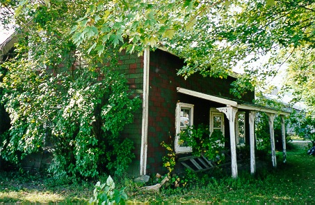
The Buxton Settlement National Historic Site of Canada is a cultural landscape of some 4,680 hectares. It is a primarily agricultural landscape, comprised of flat, worked fields defined by deep drainage ditches and a grid of intersecting roads. Homesteads are scattered throughout the settlement area including its two hamlets, South and North Buxton, which also contain important religious, educational and cultural institutions associated with the settlement's founding by Underground Railroad refugees.
Heritage value
Buxton Settlement National Historic Site of Canada was designated because:
- this cultural landscape, through the retention of land-use patterns and built resources, speaks to the successful realization of the block or planned refugee settlement in Canada;
- the cultural landscape continues as a living memorial to its founders and to the courage of every Underground Railroad refugee who took their life in their hands and chose Canada as their home.
The heritage value of this site resides in the site's illustration of a successful Underground Railroad refugee block settlement through the survival of land-use patterns and associated built resources.

© Parks Canada
Established as the Elgin Settlement at Buxton, Ontario, the Buxton Settlement survives today as a distinct cultural landscape, one that continues to function as a community while preserving tangible survivals from its historic past. It was founded in 1849 by Irish Presbyterian Minister, Reverend William King and 15 former American slaves who, with other Underground Railroad (UGRR) refugees and abolitionists, purchased a 4,680 hectare tract of land as a joint stock company. Settlers cleared the land and established farms on 50-acre (202,342 square metre) plots which they purchased over time. By 1859, the settlement reached its peak population of over 1,000 residents served by three integrated schools, two temperance hotels, a general store, a post office, a sawmill, a brickyard, a grist mill and a pearlash factory. In 1873, its objectives achieved, the company was disbanded but the community survived.
Sources: Historic Sites and Monuments Board of Canada, Minute, March 1998; Commemorative Integrity Statement, 2002.
Character-defining elements
© Parks Canada
Elements which characterize the heritage value of the Buxton Settlement as an UGRR block settlement include:
- the agricultural land-use patterns expressed through open spaces with field plots demarcated by hedgerows, lilies, tree lines, or differing planting patterns and remnants of the original planned settlement seen in surviving 50-acre (20.2 hectares) plots;
- the road grid following originally surveyed north-south roads and east-west concession lines;
- the settlement nodes of North and South Buxton characterized by low-density, small-scale housing and modest institutional buildings set amongst outbuildings, lawns, and trees;
- scattered homesteads along roadways;
- scattered woodlots;
- system of drainage ditches parallelling the road grid;
- graveyards and cemeteries associated with churches and/or homesteads;
- surviving landscape elements including North Buxton mill pond, archaeological remnants of former industrial buildings, the first railway line, tramway and lakeshore loading site;
- the sentinel Pear Tree associated with traditional homecoming in North Buxton.
The National Program of Historical Commemoration relies on the participation of Canadians in the identification of places, events and persons of national historic significance. Any member of the public can nominate a topic for consideration by the Historic Sites and Monuments Board of Canada.
- Date modified :