
Nahanni National Park Reserve of Canada Management Plan, 2021
Nahanni National Park Reserve
Title: Nahanni National Park Reserve of Canada Management Plan, 2021
Organization: Parks Canada Agency
Note to readers
The health and safety of visitors, employees and all Canadians are of the utmost importance. Parks Canada is following the advice and guidance of public health experts to limit the spread of COVID 19 while allowing Canadians to experience Canada’s natural and cultural heritage.
Parks Canada acknowledges that the COVID-19 pandemic may have unforeseeable impacts on the Nahanni National Park Reserve of Canada Management Plan. Parks Canada will inform Indigenous communities, stakeholders and the public of any such impacts through its annual implementation update on the implementation of this plan.
Table of contents
Maps and figure
Foreword

Minister of Environment and Climate Change and Minister responsible for Parks Canada
Canada’s national parks, national historic sites and national marine conservation areas belong to all Canadians and offer truly Canadian experiences.
These special places make up one of the finest and most extensive systems of protected natural and cultural heritage areas in the world.
The Government is committed to preserving our natural and cultural heritage, expanding the system of protected places and contributing to the recovery of species-at-risk. At the same time, we must continue to offer new and innovative visitor and outreach programs and activities so that more Canadians can experience Parks Canada places and learn about our environment, history and culture.
This new management plan for Nahanni National Park Reserve of Canada (Nahʔą Dehé) supports this vision.
Management plans are developed through extensive consultation and input from various people and organizations, including Indigenous peoples, local and regional residents, visitors and the dedicated team at Parks Canada.
National parks, national historic sites and national marine conservation areas are a priority for the Government of Canada. I would like to thank everyone who contributed to this plan for their commitment and spirit of co-operation.
As the Minister responsible for Parks Canada, I applaud this collaborative effort and I am pleased to approve the Nahanni National Park Reserve of Canada Management Plan.
Recommendations
Recommended by:
Ron Hallman
President & Chief Executive Officer
Parks Canada
Andrew Campbell
Senior Vice-President, Operations
Parks Canada
Keyna Norwegian
Nahʔą Dehé Consensus Team
Dehcho First Nations representative
Darrell Betsaka
Nahʔą Dehé Consensus Team
Nahʔą Dehé Dene Band representative
Steve Vital
Nahʔą Dehé Consensus Team
Nahʔą Dehé Dene Band representative
George Tsetso
Nahʔą Dehé Consensus Team
Dehcho First Nations representative
Jonah Mitchell
Field Unit Superintendent
Southwest Northwest Territories Field Unit
Parks Canada
Lisa McDonald
Nááts’įhch’oh Management Committee
Nahʔą Dehé Consensus Team dual representative
Executive summary
Nahanni National Park Reserve (Nahanni) was established in 1976 with the original boundary containing an area of 4,766 square kilometres. In 2009, with support from the Dehcho First Nations and Nahʔą Dehé Dene Band, the park reserve was expanded to an area of approximately 30,050 square kilometres, making it the third largest national park in Canada. The expansion area included protection of the unique features of the Ram Plateau and North Nahanni Karst, the Northwest Territories’ largest glaciers, and important habitat for species at risk such as grizzly bears and the northern mountain population of the woodland caribou. In 1978, the original park reserve boundary received World Heritage Site status, one of the first in the world, by the United Nations Education, Science and Cultural Organization’s (UNESCO) World Heritage Convention. In 1987, a portion of the South Nahanni River within the original boundary was designated a Canadian Heritage River.
Under the Nahʔą Dehé Interim Park Management Arrangement (2001), the park reserve is co operatively managed by the Dehcho First Nations, Nahʔą Dehé Dene Band and Parks Canada through the Nahʔą Dehé Consensus Team. This management plan was developed with the Nahʔą Dehé Consensus Team as well as through consultation and engagement with Indigenous government organizations, business licence holders, political leaders, regional community organizations, environmental non-government organizations and the general public. The vision, key strategies, objectives and targets reflect what was heard and provide a solid framework to guide future park management.
This management plan sets a vision for the future of Nahanni, with strategies and objectives aimed at reaching that vision. As such, this plan is the main guide for the management of Nahanni, and an important accountability document for Indigenous peoples and Canadians as to how the park will be managed.
Five key strategies are identified in the plan to guide the work of managing the park for the foreseeable future. Key strategy 1 focuses on sharing the stories, history and culture of the Dene as a central aspect of the visitor experience within a pristine wilderness setting. Key strategy 2 focuses on fostering traditional and contemporary Dene knowledge in management decisions, as well as engaging the next generation in stewardship of the park reserve. Key strategy 3 focuses on the emerging environmental challenges facing Nahanni and active maintenance of the ecological integrity within the park. Key strategy 4 focuses on protection of water resources for the future and working with partners and communities to maintain water quality. Key strategy 5 focuses on reconciling relationships with Indigenous rights holders.
This management plan must be reviewed in ten years’ time with the Nahʔą Dehé Consensus Team, Indigenous rights holders and public consultation. However, a management plan review may occur sooner if there is significant change in the strategic direction or in the management priorities for the heritage place or where required by other agreements.
Introduction
Parks Canada administers one of the finest and most extensive systems of protected natural and historic places in the world. The Agency’s mandate is to protect and present these places for the benefit and enjoyment of current and future generations. Future-oriented, strategic management of each national park, national marine conservation area, heritage canal and those national historic sites administered by Parks Canada supports the Agency’s vision:
Canada’s treasured natural and historic places will be a living legacy, connecting hearts and minds to a stronger, deeper understanding of the very essence of Canada.
The Canada National Parks Act and the Parks Canada Agency Act require Parks Canada to prepare a management plan for each national park. The Nahanni National Park Reserve of Canada Management Plan, once approved by the Minister responsible for Parks Canada and tabled in Parliament, ensures Parks Canada’s accountability to Canadians, outlining how park management will achieve measurable results in support of the Agency’s mandate.
Under the Nahʔą Dehé Interim Park Management Arrangement (2001), Nahanni National Park Reserve is co-operatively managed by the Dehcho First Nations, Nahʔą Dehé Dene Band and Parks Canada through the Nahʔą Dehé Consensus Team. This management plan was developed with the Nahʔą Dehé Consensus Team. Indigenous rights holders, Canadians, and environmental non-government organizations were also involved in the preparation of the management plan, helping to shape the future direction of the national park reserve. The plan sets clear, strategic direction for the management and operation of Nahʔą Dehé by articulating a vision, key strategies and objectives. Parks Canada will report annually on progress toward achieving the plan’s objectives and will review the plan every ten years or sooner, if required.
This plan is not an end in and of itself. Parks Canada will maintain an open dialogue on the implementation of the management plan, to ensure that it remains relevant and meaningful. The plan will serve as the focus for ongoing engagement on the management of Nahanni National Park Reserve in years to come.
Significance of Nahanni National Park Reserve
The term “Nahanni” originates from Nahʔą Dehé, the Dehcho Dene name for what is known as Nahanni National Park Reserve. Nahʔą Dehé is commonly referenced in park administration and operations, it is used interchangeably with Nahanni and park reserve. The park reserve overlaps with distinct and shared territories of several Indigenous communities with the land, water and resources in Nahanni sustaining generations of Dehcho Dene and Métis, Nahʔą Dehé Dene, Sahtu Dene and Métis, Kaska Dena and the Acho Dene Koe First Nation. It is recognized that each Indigenous community use their own specific names for landmarks, waterways and resources within the park reserve. These Indigenous communities continue using traditional land routes and waterways in the park reserve to access their cultural sites and wildlife harvesting areas (Map 1).
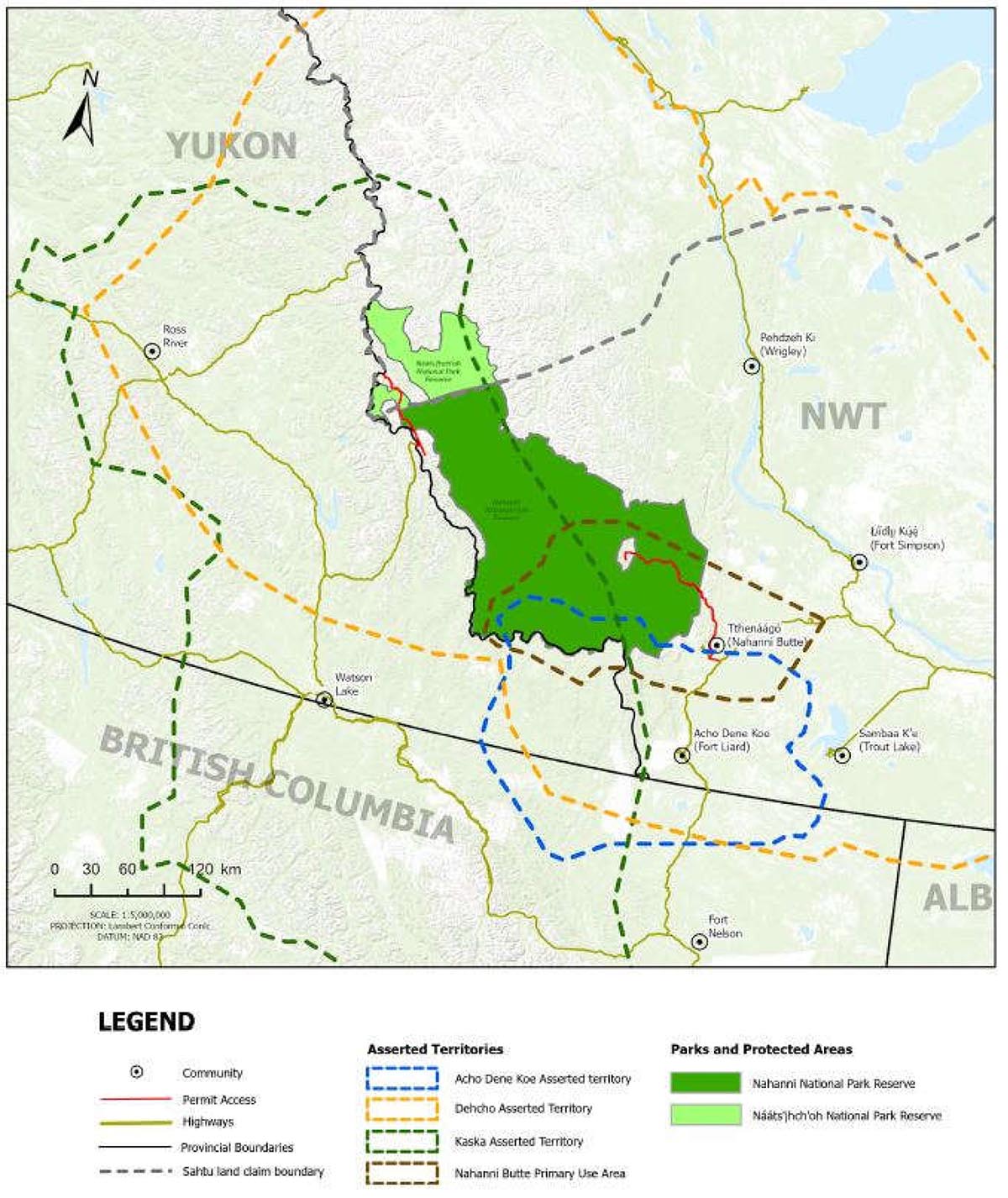
Map 1. Indigenous territories in Nahanni National Park Reserve
(Not to scale and adapted from the department of Crown-Indigenous Relations and Northern Affairs Canada.)
Indigenous territories in Nahanni National Park Reserve — Text version
This map identifies four Indigenous rights holders who have asserted territories in Nahanni National Park Reserve: the Acho Dene Koe Asserted Territory, the Kaska Dena Asserted Territory, the Dehcho Assert Territory and the Nahanni Butte Primary Use Area.
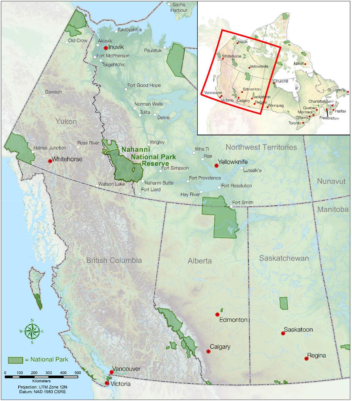
Map 2. Regional setting
Regional setting — Text version
This map details the location of Nahanni Park Reserve in relation to other national parks managed by Parks Canada in the Yukon, Northwest Territories, Alberta, Saskatchewan and British Columbia.
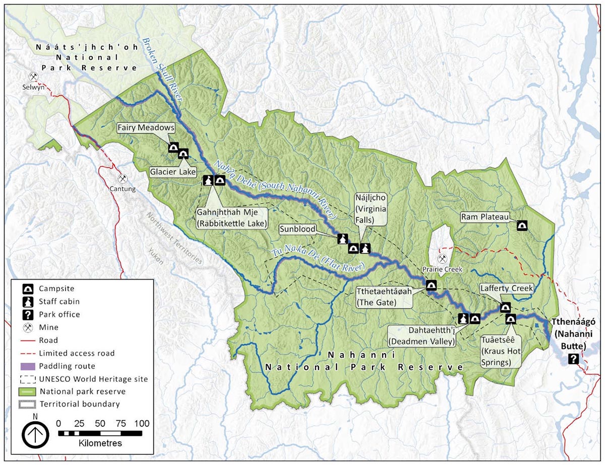
Map 3. Nahʔą Dehé, Nahanni National Park Reserve
Nahʔą Dehé, Nahanni National Park Reserve — Text version
This map details the boundaries of the Nahanni park reserve, the hydrographic network as well as the main infrastructure of the park (roads, cabins, camping, etc).
The park reserve was established in 1976 with the original boundary containing an area of 4,766 square kilometres. In 2009, the park reserve was expanded to an area of 30,050 square kilometres, making it the third largest national park in Canada. The Dehcho Elders and leadership supported expansion to achieve their desire to protect water quality for the seventh generation Footnote 1. The expansion area also included protection of the unique features of the Ram Plateau and North Nahanni Karst, the Northwest Territories’ only glaciers, and important habitat for species at risk such as grizzly bears and the northern mountain population of the woodland caribou.
In 1978, the original park reserve boundary received World Heritage Site status, one of the first in the world, by the UNESCO World Heritage Convention. The park was designated a UNESCO World Heritage site as it is a place that exhibits outstanding examples of major stages in the earth’s evolutionary history, significant ongoing geological processes and superlative natural phenomena, formations and features of exceptional natural beauty. In 1987, a portion of the South Nahanni River within the original boundary was designated a Canadian Heritage River for its outstanding recreational opportunities in a wilderness area of great scenic beauty.
Situated in the Dehcho Region in the southwest corner of the Northwest Territories (Map 2), Nahʔą Dehé shares a boundary with Nááts’įhch’oh National Park Reserve (Nááts’įhch’oh). The South Nahanni River is the central feature of the Nahʔą Dehé. It originates at the height of land near the Northwest Territories and Yukon border, ending more than 500 kilometres downstream at its confluence with the Liard River near the community of Tthenáágó (Nahanni Butte) (Map 3). Significant features within the park reserve include Náįlįcho (also known as Virginia Falls), deep antecedent river canyons, limestone karst and pseudokarst topography, numerous thermal springs, the highest mountains and largest glaciers in the Northwest Territories, and Canada’s largest tufa mounds.
The park reserve is the only known location of a rare and an endemic plant species: the Nahanni aster. The diversity of vegetation in Nahʔą Dehé is far greater than any other area of comparable size in the Northwest Territories. The vegetation community is predominantly boreal forest, with a transition from lowland wet areas to alpine tundra. Over 230 genera and 700 species of vascular plants have been documented within the park, which provides important habitat for 42 different species of mammals including species at risk. Further, the park reserve includes a diversity of birds with a mixture of cordilleran, boreal and great plain species. Sixteen fish species have been recorded within the South Nahanni watershed including three species that are unique to the region: spoonhead sculpin, trout-perch, and spottail shiner.
Nahʔą Dehé has been co-operatively managed with the Dehcho First Nations since 2003 when the Interim Park Management Arrangement was signed between the Government of Canada and the Dehcho First Nations. The Interim Park Management Arrangement established the Nahʔą Dehé Consensus Team that is comprised of representatives from the Dehcho First Nations, Nahʔą Dehé Dene Band, and Parks Canada. The Sahtu Dene and Métis joined the Nahʔą Dehé Consensus Team following the establishment of Nááts’įhch’oh. The Interim Park Management Arrangement was born from the land claim negotiation between the Dehcho First Nations and Canada known as the Dehcho Process. The Acho Dene Koe First Nation and the Kaska Dena are not active participants in the Dehcho Process land claim negotiation. They do not have representation on the Nahʔą Dehé Consensus Team; as a result their engagement has been limited in park management. This is an area for improvement to be shared by Parks Canada, the Kaska Dena and Acho Dene Koe First Nation.
Approximately 3,900 people reside in the communities closest to the park: Tthenáágó (Nahanni Butte), Acho Dene Koe (Fort Liard), Łı́ı́dlı̨ı̨ Kų́ę́ (Fort Simpson), Sambaa K’e (Trout Lake), Pehdzeh Ki (Wrigley), Watson Lake (Yukon) and Ross River (Yukon). The administrative office for the park reserve is located in Łı́ı́dlı̨ı̨ Kų́ę́ which is the primary gateway community for visitors and park staff. There is also a seasonal Parks Canada office in Tthenáágó, the closest community to the park reserve. Access to Nahʔą Dehé is primarily by chartered aircraft from gateway locations in the Northwest Territories. There are a few business operators in the Yukon and northern British Columbia that offer chartered flight services into the park reserve.
Planning context
National Park Reserve status
Parks Canada uses national park reserve designations where there are outstanding or ongoing land claim negotiations between the Government of Canada and Indigenous government organizations. The national park reserve status allows protection, conservation and operation of a national park reserve notwithstanding land claim negotiations or Indigenous rights. Section 39 of the Canada National Parks Act (the Act) stipulates that subject to sections 40 to 41.5, the Act applies to a national park reserve as if it were a national park. Section 40 states that the application of the Act to a park reserve is subject to the carrying on of the traditional renewable resource harvesting activities by Aboriginal persons. Traditional harvesting activities of Indigenous persons in national park reserves are protected by legislation, and Nahanni is listed in Schedule 2 of the Act as a park reserve.
The Dene and Métis
In the early 1900s, Government policies to establish settlements at fur-trading posts discouraged Dene and Métis from living on the land. Assimilation programs such as residential schools had profound and lasting impacts on the Dene and Métis and their way of life. As a result, Dene Zhatie (the Dene language) faces risk of extinction in the next 30 to 50 years. There is a growing resurgence amongst the Dene and Métis to reverse the impacts of colonization by revitalizing their cultures and language through community-based initiatives. This has not come without challenges as cultural revitalization efforts are competing with disruptions stemming from a modern wage economy, reduced time on the land, and immersion in the digital information age. For these reasons, a key priority for the Nahʔą Dehé Consensus Team over the next ten years is to work with community organizations to support ongoing and new cultural revitalization activities and to reconnect local Dehcho youth and Elders to Nahʔą Dehé. Parks Canada will also work with the Sahtu Dene and Métis, Kaska Dena and the Acho Dene Koe First Nation to implement this plan.
Indigenous rights holders
Map 1 identifies four Indigenous rights holders who have asserted territories in Nahanni National Park Reserve. The Acho Dene Koe First Nation and the Kaska Dena are Indigenous rights holders who have not been participants in the Dehcho Process land claim negotiation, and as a result they do not have representation in co operative management. This is an area that requires significant improvement. The Kaska Dena include four rights holders: Liard First Nation, Ross River Dena Council, Kwadacha Nation, and Dease River First Nation. The Liard First Nation worked with Parks Canada during the final stages of the management plan to address the missing links in the relationship between Parks Canada and Indigenous rights holders. There is renewed and shared interest in developing and improving the relationship between Parks Canada, the Acho Dene Koe First Nation, the Liard First Nation and Kaska Dena during the life of this plan. This task must be shared by all participants.
Ecological integrity and asset sustainability
A vast majority of the park reserve is considered to be undisturbed wilderness. Fire and flooding are the primary natural disturbances that drive ecological processes. Fires are allowed to proceed naturally in the majority of the park unless they threaten human safety or park reserve infrastructure. Data gathered through research and monitoring is showing that climate change is influencing fluctuations in water and fire cycles. The impacts of climate change are a concern for the park reserve and difficult to mitigate at the park level. Over the next ten years it will be important to consider the remote nature of the park reserve and effects from climate change (e.g., receding glaciers, deteriorating permafrost and fluctuations in weather patterns), which can result in inherent logistical, financial, and engineering challenges related to long-term management of Nahʔą Dehé.
Visitation
Nahʔą Dehé is internationally renowned as a premier wilderness river park reserve with its main visitor locations being Nái̖li̖cho, Gahnįhthah Mįe (also known as Rabbitkettle Lake), Glacier Lake and Cirque of the Unclimbables. The park reserve is central to the tourism industry in the region and as a result, collaborates with partners and stakeholders at community, regional and territorial levels. Visitation is made possible by way of numerous partnerships amongst licensed outfitters, air charter companies, local restaurants, retailers, and taxis. Close working relationships with all partners are key to sustainable ecotourism in Nahʔą Dehé.
In 2018, Nahanni had 899 visitors, slightly below the ten-year average of 920 visitors per year. Approximately 66 percent of visitors paddle the South Nahanni River and 59 percent of those visitors use a licensed outfitter. The historical visitation trends are modest and stable, which is impressive considering its remote fly-in location. Visitors to the park reserve receive a true wilderness experience that integrates traditional and contemporary Dene knowledge. Incremental growth to visitation without careful management has the potential to impact park resources, infrastructure, and wilderness character and may influence the quality of the interactions with both the natural and cultural resources in high-use or sensitive areas. Over the next ten years, it will be important to balance potential for growth in visitation and management of infrastructure to ensure the authentic wilderness park experience is not compromised.
Resource development and prohibited access
Three mining sites exist in the region outside the park boundaries (Map 3); the Cantung mine, a Tungsten producer; the Prairie Creek mine; and the Selwyn Chihong Mining Limited exploration properties at Don Camp. Cantung is an end-of-life project with associated water and water quality management issues. The Prairie Creek mine and winter road were established in the early 1980s, but the mine never reached full production and is currently in a state of care and maintenance. The Selwyn Chihong exploration properties and road were developed in the late 1970s and the all-season access road through Nahanni and Nááts’įhch’oh was rehabilitated in 2014. These projects are currently in various stages of reactivation.
The Canada National Parks Act was amended to expand the park reserve boundaries and provided special provisions for Parks Canada to issue permits to Prairie Creek and the Selwyn Project for the use of existing access roads passing through Nahanni and Nááts’įhch’oh national park reserves. Upstream industrial activities, as well as existing and proposed industrial roads passing through Nahanni, have the potential to impact the ecological integrity and cultural resources (including archaeological sites) in the park reserve. Furthermore, hunting activities along the existing Selwyn road continue to be a concern for Indigenous co operative management partners in Nahanni and Nááts’įhch’oh. The development of the Prairie Creek access road may further exacerbate unauthorized access and the potential for illegal poaching. Over the next ten years, the two mine access roads and associated activities will require careful management in co operation with Indigenous communities, and through consultation with mining companies and their contractors.
The next ten years will see the national park reserve, in collaboration with partners and stakeholders, continue a proactive approach toward sustainable park management to ensure that future generations can enjoy this iconic Canadian destination without impairing the natural and cultural values that define it. This management plan was developed with the Nahʔą Dehé Consensus Team, as well as through consultation and engagement with Indigenous government organizations, business licence holders, political leaders, regional community organizations, environmental non-government organizations and the general public. The vision, key strategies, objectives and targets reflect what was heard and provide a solid framework to guide future park management.
Vision
The vision presented in this management plan expresses the desired state of Nahanni in ten years. The key elements are built upon the 2010 management plan vision and input from the Nahʔą Dehé Consensus Team, Liard First Nation, stakeholders and Canadians.
Nahʔą Dehé is an iconic place, globally renowned for its geologic landforms, sheer granite spires, vast alpine plateaux and, its heart, the South Nahanni River, a Canadian Heritage River. As a UNESCO World Heritage site, Nahʔą Dehé remains a rich cultural landscape that tells the stories of its diverse ecology whether at the thundering waters of Náįlįcho or the largest Canadian tufa mounds at the sacred Gahnįhthah Mįe or at the spectacular granite peaks of the Cirque of the Unclimbables. Nahʔą Dehé is committed to protecting a largely undisturbed wilderness, where fires and floods share the land, and naturally-occurring plant and diverse animal species, including the woodland caribou, moose and arctic grayling persist.
Indigenous communities and cultures are strongly connected to their lands and waters in the park reserve. Nahʔą Dehé offers a special place for Indigenous communities to pursue cultural revitalization, renewal and reconnection. Nahʔą Dehé will be protected through the wisdom and guidance of the Dene Elders who have said ‘being on the land protects the land’. Traditional harvesting continues as an integral and sustainable part of the ecosystem. Indigenous laws, values and principles are rooted in Nahʔą Dehé, connecting the next generation to the land and their ancestors. The park reserve continues to be a model of co operative management, where communities, partners, Indigenous rights holders and stakeholders are involved in the stewardship of Nahʔą Dehé, ensuring appreciation and respect for the land and water continues into future generations.
Visitors are invited to this spectacular wilderness by the Dene, who share the stories of their ancestors. Climbers, hikers, paddlers and visitors of all kinds find personal inspiration and connection to this immense land and the Dene. Visitors who make the financial and time investments for this journey are rewarded with a depth of adventure and cultural experiences that is life changing.
5.0 Key strategies
Five key strategies frame the management direction for Nahʔą Dehé for the next ten years. The strategies and corresponding objectives and targets focus on achieving the vision for the park reserve through an integrated approach to park management. Unless otherwise specified, all targets are meant to be achieved within the ten-year period of the plan. Yearly implementation updates will be provided to engage the Nahʔą Dehé Consensus Team, Indigenous rights holders, stakeholders and Canadians.
Key strategy 1
Nahʔą Kué/Our Home – Sharing the heart of the Dehcho
Sharing the stories, history and culture of the Dene in a pristine wilderness setting is vital to the visitor experience for Nahʔą Dehé. A journey into Nahʔą Dehé is potentially transformative for visitors who will leave with a greater understanding and appreciation for Dene culture. To that end, Nahʔą Dehé continues to rely on strategic partnering to support a strong and sustainable tourism economy. This is central to providing high-quality, authentic cultural and wilderness experiences and achieving long-term asset sustainability. Over the next ten years Parks Canada and the Nahʔą Dehé Consensus Team will engage with other government partners with mandates to assist in economic development, to leverage new tourism initiatives, as well as to support tourism business training opportunities for local Indigenous entrepreneurs. Over the next five years, Parks Canada will work with the communities to establish new offices in Łı́ı́dlı̨ı̨ Kų́ę́ (Fort Simpson) and Tthenáágó (Nahanni Butte).
Strategic planning focused on promotion, outreach and connecting visitors to the site will be essential to achieving the objectives set out in this strategy. This includes improving pre-trip planning information available to visitors, targeting key visitor markets specifically those between the ages of 25 to 34 and 35 to 44 years, and developing a strategy to ensure management practices respond to the needs and usage of mountaineers. This strategy will be developed within five years of approval of the management plan and implemented over the life of this plan.
Objective 1.1
Nahanni continues to target and attract visitors seeking high-quality wilderness experiences, while balancing protection and presentation.
Targets
- Over the next ten years, visitation on the South Nahanni River during peak visitor season is maintained within 2 percent of the average visitation from 2014 to 2018 Footnote 2.
- Over the next ten years, visitation on the South Nahanni River during the spring and fall shoulder seasons grows 10 percent from the average visitation in 2014 to 2018.
Objective 1.2
Management of park infrastructure takes into account impacts from climate change, carbon footprint reduction and the interests and views of the Nahʔą Dehé Consensus Team, Indigenous rights holders and stakeholders.
Targets
- Develop a strategic asset management plan by 2025.
- All new asset development/renovation complies with the strategic asset management plan.
Objective 1.3
Visitors continue to report high-quality wilderness recreation and cultural experiences.
Targets
- Visitor satisfaction and pre-trip planning ratings meet performance targets in the next State of the Park Assessment.
- Participation in visitor feedback surveys is increased by 15 percent from 2019 levels by 2030.
Objective 1.4
Local Indigenous eco-tourism partnerships are enhanced.
Targets
- A licence for river outfitting is reserved for a Dehcho owned and operated eco-tourism business.
- Parks Canada supports local communities and partners to develop a minimum of two new Dene tourism products for park visitors by 2030.
Objective 1.5
Nahʔą Dehé remains internationally renowned as a premier wilderness destination.
Targets
- Virtual reach, through social media and the website, increases by 10 percent over the next ten years from 2019 levels.
- Media interest and publications highlighting Nahanni National Park Reserve increases by 10 percent from 2019 levels.
- Two additional promotional and marketing partnerships will be formed by 2030.
Key strategy 2
Dene Náothę – The Dene worldview
Parks Canada, the Dehcho First Nations and the Nahʔą Dehé Dene Band continue to strengthen their relationship in a way that incorporates Dene values and principles. Engaging Dene youth in stewardship of the park reserve is of primary importance to keep their ancestors’ legacy alive, and to foster traditional and contemporary Dene knowledge in management decisions. Over the next ten years Canadians will have a greater understanding and appreciation for the importance of thriving Indigenous cultures in Nahʔą Dehé.
Objective 2.1
Dene Zhatie, the Dene language and culture of Nahʔą Dehé, is promoted, celebrated, and integrated into visitor experiences.
Targets
- Parks Canada, Dehcho First Nations and Nahʔą Dehé Dene Band collaborate to facilitate a Dene Zhatie cultural learning experience in the park reserve for community members and visitors every two years.
- All new non-personal media products (i.e., brochures, exhibits, information panels) include Dene place names by 2030.
- A minimum of two products with Dene language and phonetic spelling are developed annually.
Objective 2.2
The Dene have a stronger connection to Nahʔą Dehé.
Targets
- Parks Canada works with Indigenous co operative management partners to facilitate annual opportunities for youth and Elders to partake in Dene cultural revitalization efforts in Nahʔą Dehé.
- A minimum of two educational and outreach activities in local and regional schools are pursued annually.
- Local and regional schools visit Nahʔą Dehé a minimum of three times by 2030.
Key strategy 3
Nahʔą Dehé Kˊeodhi – Taking care of Nahʔą Dehé
The emerging environmental challenges facing Nahʔą Dehé are complex, including managing for species at risk, climate change, proposed resource development, unauthorized access and illegal harvesting. Research and monitoring information, Dene Knowledge and active management strategies will be essential to maintain ecological integrity in Nahʔą Dehé. As a result, there will be an emphasis on creating efficiencies in the ecological integrity monitoring program. This includes strategically reviewing the current monitoring program, using new and innovative technology to measure fish presence in streams and ensuring that the information gaps for woodland caribou (Northern Mountain population) are addressed over the next five years.
The longer-term focus will be incorporating Dene Knowledge into Parks Canada’s regulatory processes as well as co-ordinating with our partners in supporting park-based, community-led guardian initiatives for stronger park management over the next ten years. Parks Canada will work with Dehcho, Kaska Dena, and Sahtu Dene and Métis to update the existing harvesting protocols.
Parks Canada will work with the Nahʔą Dehé Consensus Team to set management priorities for cultural resources in the park reserve including outlining relevant criteria. This includes developing a monitoring plan for cultural resources that considers research and monitoring opportunities as a result of climate change. The cultural resource monitoring plan will be developed within five years of this park management plan being approved and implemented over the life of this plan.
Objective 3.1
Ecological integrity of Nahʔą Dehé is maintained without significant impact from resource development projects.
Targets
- Permits and licences for proposed mining road developments passing through Nahʔą Dehé meet all legal requirements over the next ten years, including where necessary, in collaboration with Nááts’įhch’oh National Park Reserve.
- Continue to monitor, review and comment on all water licences for upstream mine sites and exploration so water quality is protected over the next ten years.
- The trend for caribou herds remains stable in the next State of Park Assessment.
Objective 3.2
Information and prevention strategies related to unauthorized activities in Nahʔą Dehé are improved.
Targets
- Non-personal media (i.e., warning and wayfinding signs, panels), increases by 10 percent from 2019 levels by 2025 (e.g., inclusion of harvesting protocol information near the Lower South Nahanni River and Howards Pass Access Road).
- Law enforcement reporting tools and products are shared with communities and businesses in Tthenáágó, Acho Dene Koe, Łı́ı́dlı̨ı̨ Kų́ę́ and Watson Lake by 2025.
Objective 3.3
The sustainability of the ecological integrity monitoring program is improved.
Targets
- Monitoring workshops with Indigenous communities are held every two years.
- Work with Indigenous co operative management partners to support a community-led Guardian program by 2025.
- Monitoring stations are established to represent all ecoregions added in the park reserve by 2025.
- All guidelines in the ecological integrity monitoring plan are met over the next ten years.
Objective 3.4
Condition ratings for the cultural resources in the park are established.
Targets
- A Cultural Resource Values Statement is completed by 2025.
- Cultural resource indicators are rated in the next State of the Park Assessment.
Key strategy 4
Yundáa Gogha Tu Kˊehodí – Waters for life
Water quality is essential to cultural experiences for the Dene and pristine wilderness experiences for visitors. Protecting water resources for future generations is a top priority of the Dene, who recognize that clean water is essential to health and well-being. Climate change, human waste management and resource development pressures adjacent to the park have the potential to impact water resources and processes. Parks Canada will continue working with partners and communities to monitor and inform management actions that will maintain water quality.
It will be important to balance visitation levels to ensure water quality continues to be protected from human use and erosion. To begin this work, a sustainable human waste strategy will be developed outlining criteria to determine sustainable levels of visitation over the next ten years. The human waste strategy will be developed within five years of this plan being approved and implemented over the life of this plan.
Objective 4.1
Human waste management is improved to reflect best practices.
Targets
- Human waste management complies with the sustainable human waste strategy by 2030.
Objective 4.2
The water quality of Nahʔą Dehé is maintained.
Targets
- Water quality measures are maintained or improved from the 2018 State of the Park Assessment over the next ten years.
- Fish presence is maintained from the 2018 State of the Park Assessment over the next ten years.
Key strategy 5
Reconciling with Indigenous rights holders
Over the next ten years, engaging with the Acho Dene Koe First Nation and the Kaska Dena in active park management is a priority for Parks Canada and the Nahʔą Dehé Consensus Team. It will be important to ensure opportunities are provided for Acho Dene Koe First Nation and the Kaska Dena to be active participants in park management.
Building and strengthening this relationship will be a shared responsibility between Parks Canada, the Nahʔą Dehé Consensus Team, the Acho Dene Koe First Nation and the Kaska Dena. Parks Canada will work closely with willing Indigenous rights holders toward an improved and inclusive management approach. This includes establishing and developing partnerships with the Acho Dene Koe First Nation and Kaska Dena in the park reserve over the next ten years.
Objective 5.1
The relationship between Parks Canada and the Acho Dene Koe First Nation is improved over the next ten years.
Targets
- Establish face-to-face contact with the Chief and Council at minimum once per year.
- Parks Canada and Acho Dene Koe First Nation co-develop an engagement protocol, partnership or agreement by 2025.
Objective 5.2
The relationship between Parks Canada and the Kaska Dena is improved over the next ten years.
Targets
- The park superintendent meets with the willing Chiefs and Councillors from the four Kaska rights holders at least once over the next five years.
- Parks Canada works with the Kaska rights holders to co-develop an engagement protocol, partnership or agreement by 2030.
- Parks Canada and Liard First Nation co-develop a co operative management agreement by 2025.
Zoning and declared wilderness area
Zoning
Zoning is an important management tool that supports the vision for Nahʔą Dehé by directing visitor use to appropriate areas of the park reserve, and ensuring that rare, sensitive, ecological or cultural areas are protected.
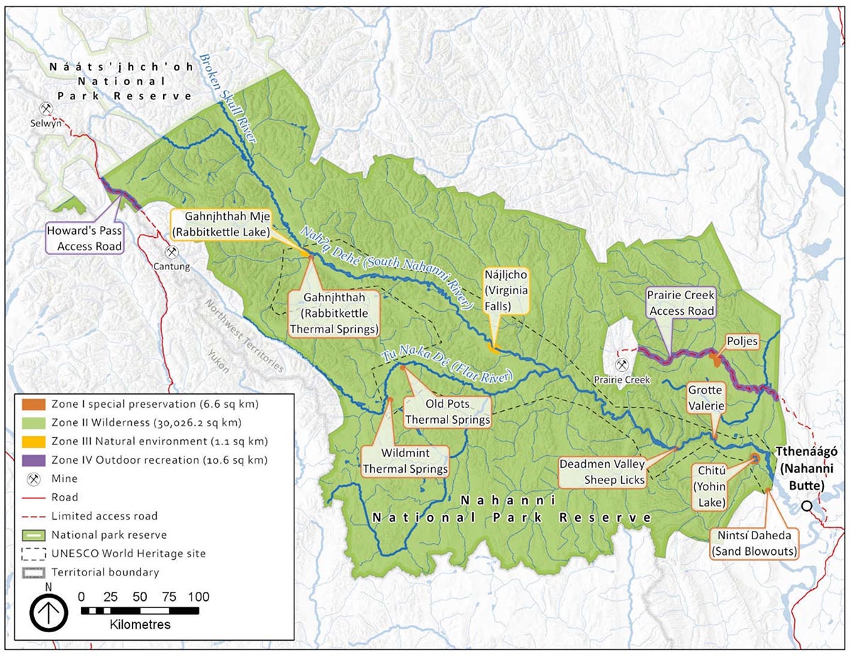
Map 4. Nahanni National Park Reserve zoning map
Nahanni National Park Reserve zoning map — Text version
This map shows the zoning system for Nahanni Park Reserve.
- Zone I – Special Preservation;
- Zone II – Wilderness;
- Zone III – Natural Environment;
- Zone IV – Outdoor Recreation; and
- Zone V – Park Services.
Parks Canada’s national park zoning system is an integrated approach to the classification of land and water areas in a national park and designates where particular activities can occur on land or water based on the ability to support those uses. The zoning system has five categories:
- Zone I – Special Preservation;
- Zone II – Wilderness;
- Zone III – Natural Environment;
- Zone IV – Outdoor Recreation; and
- Zone V – Park Services.
The zoning plan for Nahanni is illustrated on Map 4. Four of the zoning system categories apply to Nahʔą Dehé.
Zone I – Special Preservation
Zone I is the most protective category in the Parks Canada zoning system. Zone I designates are specific areas or features which deserve special preservation because they contain or support unique, threatened or endangered natural or cultural features, or are among the best examples of the features that represent a natural region. Preservation is the key consideration. Motorized access and circulation will not be permitted. In cases where the fragility of the area precludes any public access, every effort will be made to provide park visitors with appropriate off-site programs and exhibits interpreting the special characteristics of the zone.
There are seven Zone I areas encompassing a total area of 6.6 square kilometres or 0.022 percent of park reserve lands. The following areas are included in Zone I:
- Gahnįhthah – tufa mounds – the only Zone I area in the park reserve where public access is permitted through a guided 3.5 kilometre hike.
- Grotte Valerie
- Wildmint thermal springs
- Old Pots thermal springs
- Deadman Valley Sheep Licks
- Nintsi Daheda (Sand Blowouts)
- Chitu (Yohin Lake)
- Poljes Footnote 3
Zone II – Wilderness
Zone II Wilderness areas are meant to protect representative natural landscapes where visitors can experience nature with minimal human intrusion or facilities. The visitor experience in these areas is focused on self-propelled activities, and motorized access is not permitted. This does not impact Indigenous users who continue to use motorized vessels to pursue traditional and cultural activities. Air access is permitted in this zone at designated landing sites (Map 5) with an Aircraft Access Permit.
The vast majority of Nahʔą Dehé is Zone II, encompassing 30,026 square kilometres or 99.94 percent of the park reserve.
Zone III – Natural Environment
Zone III areas are managed as natural environments that are capable of supporting a range of visitor experiences. These areas enable visitors to enjoy and learn about the park’s natural and cultural features through outdoor recreational and educational activities requiring minimal facilities and services.
There are two Zone III areas in Nahʔą Dehé that encompass a total area of 1.1 square kilometres or 0.0004 percent of the park reserve. This zone recognizes controls on use and facility development at these sites, while allowing for frequent air access. The Zone III areas include:
- Náįlįcho
- Gahnįhthah Mįe
Zone IV – Outdoor Recreation
Zone IV are limited areas which are capable of accommodating a broad range of opportunities for understanding, appreciation and enjoyment of the park's heritage values and related essential services and facilities, in ways that impact the ecological integrity of the park to the smallest extent possible, and whose defining feature is direct access by motorized vehicles. Park management plans may define provisions for limiting private motorized access and circulation.
When the park was expanded in 2009, the Canada National Parks Act was amended to include the ability for Parks Canada to permit two existing exploration and mine site access roads: the Howard’s Pass Access Road and the Prairie Creek Access Road. Both are permitted for specific purposes and all access on these roads in Nahanni requires a permit, with the exception of access by traditional users.
The Howard’s Pass Access Road (2.2 square kilometres) and the Prairie Creek Access Road (8.4 square kilometres) in Nahanni make a small portion of lands designated Zone IV, encompassing a total of 10.6 square kilometres or 0.035 percent of the park reserve. This zone was selected because the defining feature is direct access by motorized vehicle. Access by motorized vehicles will be carefully managed by Parks Canada.
Wilderness area declaration
The intent of legally designating a portion of a national park as “wilderness” is to maintain its wilderness character in perpetuity. Only activities that are unlikely to impair the wilderness character of the area may be authorized within the declared wilderness area of Nahanni National Park Reserve.
In 2004, 98 percent of the original 1976 boundary (as shown in Map 4 as the UNESCO World Heritage site boundary) was declared a Wilderness Area. The expansion area has not been declared a Wilderness Area.
Aircraft access
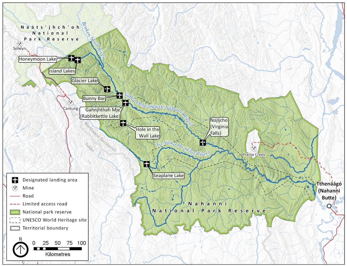
Map 5. Nahanni National Park Reserve designated landing areas
Nahanni National Park Reserve designated landing areas — Text version
This map shows the various designated landing areas on the territory of the Nahanni Park Reserve. There are landing areas at:
- Honeymoon Lake
- Island Lakes
- Glacier Lake
- Bunny Bar
- Gahnįhthah Mje (Rabbitkettle Lake)
- Hole in the Wall Lake
- Seaplane Lake
- Náįlįcho (Virginia Falls)
Access to Nahʔą Dehé is primarily by air with designated landing sites (Figure 1) in Zone II and Zone III as illustrated on Map 5. All permits are subject to the National Parks of Canada Aircraft Access Regulations. Regional air charter operators are encouraged to reduce disruption to the wilderness experience of visitors, by avoiding low-level flights along the river corridor.
Aircraft access into the park, apart from the designated access points, may be permitted by the Superintendent on a case-by-case basis. These requests will be facilitated through an application process. When making the decision for permitting access, consideration will be given to other reasonable means of access, the potential for significant adverse effects to ecological integrity, cultural values, wilderness character, public safety and enjoyment of that area by other persons.
Figure 1. Designated landing areas
| Location | Aircraft | Activity | |||
|---|---|---|---|---|---|
| Float plane | Wheeled plane | Helicopter | Access and Day Use | Access | |
| Náįlįcho (Virginia Falls) | Yes | - | Yes | Yes | Yes |
| Gahnįhthah Mįe, (Rabbitkettle Lake) | Yes | - | Yes | - | Yes |
| Bunny Bar | Yes | Yes | Yes | - | Yes |
| Island Lake | Yes | - | Yes | - | Yes |
| Honeymoon Lake | Yes | - | Yes | - | Yes |
| Glacier Lake | Yes | - | Yes | Yes | Yes |
| Seaplane Lake | Yes | - | Yes | - | Yes |
| Hole In the Wall | Yes | - | Yes | - | Yes |
Summary of strategic environmental assessment
Parks Canada is responsible for assessing and mitigating the impacts of management actions on ecosystems and on cultural resources. The Cabinet Directive on the Environmental Assessment of Policy, Plan and Program Proposals (2010) prepared by the Impact Assessment Agency of Canada, requires a strategic environmental assessment of all plans and policies submitted to the federal Cabinet or to a Minister for approval deemed to have important positive or negative environmental effects.
A strategic environmental assessment was undertaken on this management plan, and the management direction found within has been adjusted to respond to findings. The following is a summary of the environmental assessment:
The scope of the strategic environmental assessment included the area within the boundary of Nahʔą Dehé and considered influences from potential external stressors outside of the park. The time frame considered in the assessment was ten years from the date of the plan, at which time the plan will be reviewed. Valued Components evaluated in the strategic environmental assessment include components of the fresh water, forest and tundra ecosystems including species at risk.
Most of the Valued Components were found not to be at risk from cumulative effects, as the primary stressor to the park’s natural environment is climate change. A short analysis of cumulative effects was conducted for wide-ranging species including woodland caribou (northern mountain population), grizzly bear, and wolverine as these Valued Components are subject to multiple stressors. In addition, the management plan includes strategies to understand the impacts to a number of Valued Components including:
- collaboration, partnerships and communication as an integral part of implementing this plan;
- Nahʔą Dehé working with others to help maintain the ecological integrity of the park reserve;
- strengthening partnerships to address the emerging demands and challenges of the next ten years such as climate change, proposed resource development pressures and asset sustainability;
- integration of up-to-date climate change research and predictions into natural and cultural resource management decisions for Nahʔą Dehé;
- working with partners, Indigenous rights holders and communities to monitor and inform management actions that will maintain water quality;
- management of park visitation at sustainable levels, and ensuring human waste management practices are reviewed and monitored regularly including the development, implementation and monitoring of strategies and/or protocols;
- regular engagement of local communities in water quality monitoring programs with clear communication of results to local communities and land managers; and
- strengthening connections to and understanding of the park by increasing community presence and cultural revitalization efforts for community members.
The UNESCO World Heritage site boundary is based on the original Nahʔą Dehé boundary. The outstanding universal values for which it was designated were evaluated to ensure the management plan adequately protects them. Engagement with the Nahʔą Dehé Consensus Team was conducted and the feedback used to finalize both the management plan and strategic environmental assessment.
Contact us
For more information about the management plan or about Nahanni National Park Reserve:
Nahanni National Park Reserve
PO Box 348
Fort Simpson NT X0E 0N0
Canada
Email: pc.nahanniinfo-infonahanni.pc@canada.ca
Fax number: 867-695-2446
Publication information
© Her Majesty the Queen in Right of Canada, represented by the President & Chief Executive Officer of Parks Canada, 2021.
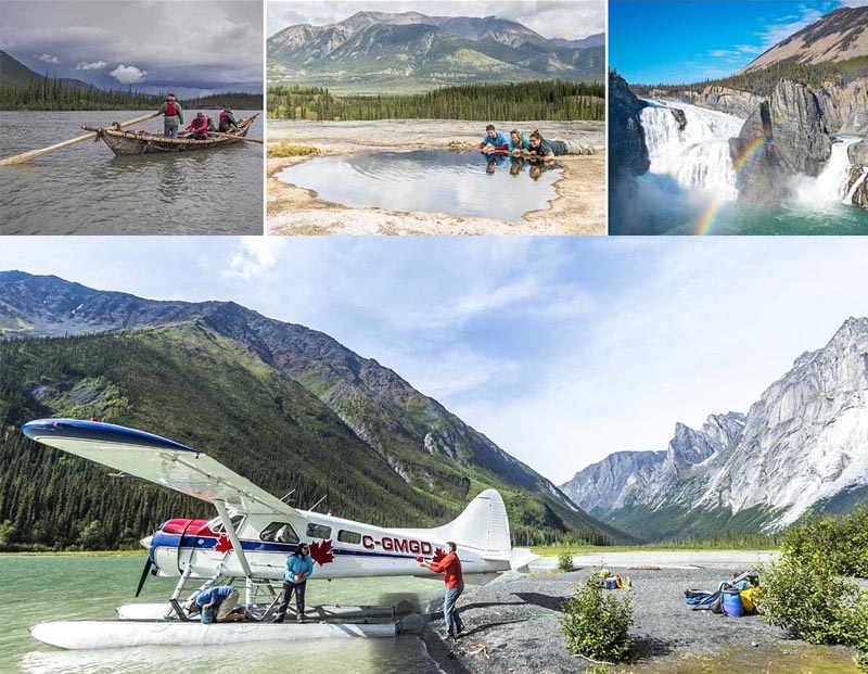
Front cover image credit:
top from left to right: Elan Productions Ltd & 90th Parallel Productions; R. Stimpson / ©Parks Canada; Aletium Ltd
bottom: F. Mueller / ©Parks Canada
Cette publication est aussi disponible en français :
Plan directeur de la réserve de parc national du Canada Nahanni, 2021
- Paper: R64-562/2020E
- 978-0-660-36176-5
- PDF: R64-562/2020E-PDF
- 978-0-660-34398-3
Related links
- Date modified :