Forillon National Park of Canada Management Plan, 2022
Forillon National Park
Note to readers
The health and safety of visitors, employees and all Canadians are of the utmost importance. Parks Canada is following the advice and guidance of public health experts to limit the spread of COVID-19 while allowing Canadians to experience Canada’s natural and cultural heritage.
Parks Canada acknowledges that the COVID-19 pandemic may have unforeseeable impacts on the Forillon National Park of Canada Management Plan. Parks Canada will inform Indigenous peoples, partners, stakeholders and the public of any such impacts through its annual implementation update on the implementation of this plan.
The Honourable Steven Guilbeault
Minister of Environment and Climate Change and Minister responsible for Parks Canada
From coast to coast to coast, national historic sites, national parks and national marine conservation areas are a source of shared pride for Canadians. They reflect Canada’s natural and cultural heritage and tell stories of who we are, including the historic and contemporary contributions of Indigenous peoples.
These cherished places are a priority for the Government of Canada. We are committed to protecting natural and cultural heritage, expanding the system of protected places, and contributing to the recovery of species at risk.
At the same time, we continue to offer new and innovative visitor and outreach programs and activities to ensure that more Canadians can experience these iconic destinations and learn about history, culture and the environment.
In collaboration with Indigenous communities and key partners, Parks Canada conserves and protects national historic sites and national parks; enables people to discover and connect with history and nature; and helps sustain the economic value of these places for local and regional communities.
This new management plan for Forillon National Park of Canada supports this vision.
Management plans are developed by a dedicated team at Parks Canada through extensive consultation and input from Indigenous partners, other partners and stakeholders, local communities, as well as visitors past and present. I would like to thank everyone who contributed to this plan for their commitment and spirit of cooperation.
As the Minister responsible for Parks Canada, I applaud this collaborative effort and I am pleased to approve the Forillon National Park of Canada Management Plan.
Recommendations
Recommended by:
Ron Hallman
President & Chief Executive Officer
Parks Canada
Andrew Campbell
Senior Vice-President, Operations Directorate
Parks Canada
Élisabeth Lacoursière
Superintendent, Gaspésie Field Unit
Parks Canada
Executive summary
Forillon National Park is located at the northeastern tip of the Gaspé Peninsula (Map 1). The park was established in 1970 with the aim of saving and representing the terrestrial natural region of the Notre-Dame and Mégantic mountains, as well as some aspects of the marine natural regions of the Laurentian Channel and the Magdalen banks, within the federal network of protected areas.
This management plan is the fifth plan created for Forillon National Park. It builds on key achievements from the 2010 management plan. Among these achievements is the improvement of relations with the local community, which is reflected in the creation of an advisory board bringing together several partners from the region and various organizations, and the collaborations developed with the Association of Persons Expropriated from Forillon and their Descendants. An agreement for the establishment of a new partnership relationship was signed in 2009 with the Micmac Nation of Gespeg in order to establish a partnership with Forillon National Park.
Ninety-five percent of the park is covered in forest, which is home to a wide range of wildlife and flora, including several species at risk. In addition to these natural resources, the park is unique in that it contains many cultural resources that reflect the past and present occupation of the area by the Mi’gmaq people as well as the commercial fishing activities that took place there until the mid-twentieth century. Many of the buildings that were used by the families of fishermen and farmers on the peninsula before the park was created still remain today and add an interesting heritage component to the park’s visitor experience. Its distinctive coastal landscape, hiking trails and campsites are increasingly popular, as reflected by the sharp increase in the number of visitors to the park since 2013.
This management plan includes a long-term vision describing Forillon National Park’s aspirations for the next 15 to 20 years. It also presents four key strategies designed to help the park achieve its vision, each strategy includes specific and measurable objectives and targets.
Key strategy 1
A vision to achieve together
This key strategy relies on close collaboration between Parks Canada and local communities and partners to promote Forillon National Park and manage the park in a more cooperative manner, which reflects regional values and concerns. This strategy also aims to continue the work undertaken with the Association of Persons Expropriated from Forillon and their Descendants and to develop collaboration with the Micmac Nation of Gespeg to encourage its participation in the management of the park. This collaboration will allow the Micmac Nation of Gespeg to promote the practice of traditional activities in their territory and the development of Mi’gmaq culture.
Key strategy 2
An evolving and resilient natural environment
This key strategy prioritizes the integrity of the park’s ecosystems. This strategy calls for particular vigilance with regard to Forillon’s coastal marine environment and its forests, which are increasingly vulnerable to the impacts of climate change.
Key strategy 3
A unique cultural heritage to protect and promote
This key strategy expresses a desire to increase knowledge about the park’s many cultural resources, better preserve them, and share their heritage value with the public. The park’s collection of historical objects, cultural landscapes and archaeological resources are covered in this strategy.
Key strategy 4
A top destination due to its wealth of natural and cultural assets
By combining the natural and cultural components, this key strategy addresses the creation of memorable moments for visitors throughout the four seasons. It aims to broaden the park’s range of services and activities so that Forillon National Park can put itself forward as a must-visit recreational tourism destination.
Two areas have been identified as requiring a targeted management approach, namely the Grande-Grave and Cap-Bon-Ami areas. Specific objectives and targets for the unique challenges of these areas are presented in the management plan.
Finally, this plan presents the zoning of Forillon National Park, which has remained unchanged since the 2010 management plan. Most of the park’s area is in Zone II – Wilderness, which provides a high degree of protection.
Introduction
Parks Canada administers one of the finest and most extensive systems of protected natural and historic places in the world. Its mandate is to protect and present these places for the benefit and enjoyment of current and future generations. Future-oriented, strategic management of each national historic site, national park, national marine conservation area and heritage canal administered by Parks Canada supports its vision:
Canada’s treasured natural and historic places will be a living legacy, connecting hearts and minds to a stronger, deeper understanding of the very essence of Canada.
The Canada National Parks Act and the Parks Canada Agency Act require Parks Canada to prepare a management plan for each national park. The Forillon National Park of Canada Management Plan, once approved by the Minister responsible for Parks Canada and tabled in Parliament, ensures Parks Canada’s accountability to Canadians, outlining how park management will achieve measurable results in support of its mandate.
The Micmac Nation of Gespeg was engaged in the development of the management plan to ensure their full participation in the implementation of the plan. The Association of Persons Expropriated from Forillon and their Descendants, the community of Gaspé, regional partners, members of the Forillon National Park Advisory Board and the Canadian public were involved in the preparation of the management plan, helping to shape the future direction of Forillon National Park. The plan sets clear, strategic direction for the management and operation of Forillon National Park by articulating a vision, key strategies and objectives. Parks Canada will report annually on progress toward achieving the plan objectives and will review the plan every ten years or sooner if required.
This plan is not an end in and of itself. Parks Canada will maintain an open dialogue on the implementation of the management plan, to ensure that it remains relevant and meaningful. The plan will serve as the focus for ongoing engagement and, where appropriate, consultation, on the management of Forillon National Park in years to come.
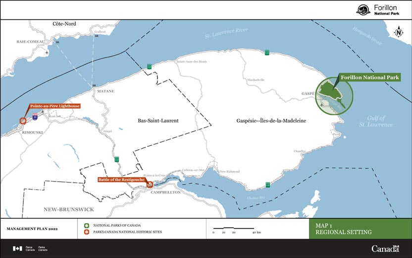
Map 1: Regional setting — Text version
This map provides regional context for Forillon National Park. Forillon National Park is located within the limits of the town of Gaspé, at the northeastern tip of the Gaspé Peninsula. To southwest of the park are Battle of Restigouche National Historic Site — located along Chaleur Bay, near Pointe-à-la Croix, on Hwy 132 — and Pointe-au-Père Lighthouse National Historic Site — located along the St. Lawrence River, near Rimouski, on Hwy 20.
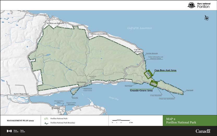
Map 2: Forillon National Park — Text version
This map outlines the park boundary of Forillon National Park, located at the northeastern tip of the Gaspé Peninsula. The administrative office for the park, as well as the Jacques cartier Monument are located in Gaspé. From west to east, along the southern boundary of the park, the following locations are marked — Penouille and Penouille Visitor Centre, Fort Peninsula, Operational Centre, Petit-Gaspé, Grande-Grave Area (a more detailed map of Grande Grave Area can be found on Map 3), L’Anse Blanchette, L’Anse-aux-Amérindiens, Cap-Gaspé. From south to north along the eastern boundary of the park, the following locations are marked — Cap-Bon-Ami Area (a more detailed map of Cap-Bon-Ami Area can be found on Map 4), Visitor Information and Descover Centre, Carricks Memorial.
Significance of Forillon National Park
Established in 1970, Forillon was the first Canadian national park in the province of Quebec. The park is located within the limits of the town of Gaspé, at the northeastern tip of the Gaspé Peninsula, one of the most popular tourist destinations in Quebec.
Forillon National Park is located on ancestral unceded Mi’gmaq territory. There are three Mi’gmaq communities in Gaspésie, the Micmacs of Gesgapegiag and the Listuguj Mi’gmaq are located in Chaleur Bay, while the Micmac Nation of Gespeg is located near the park. In Mi’gmaq, Gespeg means “where the land ends.”
Forillon National Park protects an area of 244.8 square kilometres, representative of the terrestrial natural region of the Notre-Dame and Mégantic mountains (240.4 square kilometres) and some aspects of the marine natural regions of the Laurentian Channel and the Magdalen banks (4.4 square kilometres). It is recognized as an important site for the protection of unique natural environments, a variety of habitats and of some species at risk. The marine natural region of the Laurentian Channel, which surrounds the park, is an important feeding ground for abundant and varied marine life in the summer (marine mammals, seabirds, fish). The rugged topography characteristic of the Appalachian Mountains, the wildlife and flora representative of the boreal forest, as well as the alpine tundra flora were also reasons why the area was designated a national park. Furthermore, the park’s exceptional geology and geomorphology are of national significance for the science community. The coming together of marine and terrestrial environments at Forillon is quite simply spectacular.
Forillon’s rich history, which makes the park unique due to the fact that it has high cultural value in addition to a high natural value, also contributed to its designation as a national park. Its history, as well as its cultural resources, including landscapes, are as fascinating as the wildlife and flora that call the park home. Indeed, human presence and the area’s prior occupations have shaped Forillon’s history. This territory is inhabited by the Mi’gmaq people, who have been there for thousands of years. Since the 1670s, seasonal fishers from Europe have used the “grande grave” (long gravel beach) to prepare their cod. When France ceded New France (1763), the area received an influx of people from Canada and overseas, in particular from the Channel Islands, first travelling and later settling down on the Forillon Peninsula. These communities primarily made their livings from cod fishing. Logging, and to a lesser extent whale hunting, were also sources of income for many residents. In 1970, at the request of Parks Canada, the area was expropriated by the province of Quebec, then transferred to the federal government for a period of 99 years to create a national park. Some 225 families had to leave their properties and close to 1,200 landowners lost their lumber lots and parts of their cultivated land. The Mi’gmaq lost free access to their territory. This expropriation resulted in significant changes to the former residents’ family, economic and social lives.
Today, after more than 50 years, visitors can enjoy Forillon National Park from the beginning of June until mid-October (Thanksgiving). In winter, a range of activities is offered through a partnership with the Centre culturel Le Griffon. In 2019–2020, nearly 170,000 visitors came to the park. Nearly 60 percent of the visitors were from Canada, 3 percent from the United States and 37 percent from other countries (71 percent from France). Quebecers accounted for 90 percent of all Canadian visitors to Forillon National Park, with nearly 17 percent coming from Gaspé. Camping, hiking, biking, sport fishing, swimming, interpretation activities, cruises and other water activities, visiting heritage sites and observing wildlife and landscapes are the most popular activities for visitors. In 2018, a visitor survey indicated that 80 percent of respondents were satisfied with the services and facilities provided to them. The satisfaction rate is very high for the interaction with the employees (90 percent), the cleanliness of the washroom facilities (90 percent) and family activities (85 percent). A real economic engine for the region, the park hires some 160 people annually and generates major economic benefits for the region. In 2018, total visitor spending at Forillon National Park was estimated at $9.7 million, thereby contributing nearly $4.9 million of the gross domestic product of the province of Quebec.
Planning context
This management plan is the fifth plan created for Forillon National Park. The previous management plan was published in 2010, at which point in time the park’s main challenges related to integrating the park into the community, increasing park attendance and improving the condition of park infrastructure. The plan contained strategies reflecting local and regional concerns and produced meaningful results.
Achievements since 2010
Improved relations with the local population, stakeholders and partners are among the main accomplishments made since 2010. This was made possible through various actions that created opportunities for discussion, which had a positive impact on public opinion and which increased the number of local residents participating in activities at the park. Of note was the creation of an advisory board, bringing together several community-based institutional and tourism partners from the region and various organizations; the collaborations developed with the Association of Persons Expropriated from Forillon and their Descendants; and the creation of a Parks Canada team dedicated to external relations. The efforts of the park team to enhance Forillon’s presence regionally have resulted in an increase in the number of partners who support park activities. Forillon is now recognized as a vibrant park with which it is beneficial to collaborate.
An agreement signed with the Micmac Nation of Gespeg in 2009 for the establishment of a new partnership relationship underscores the willingness to establish a relationship with this community, a relationship that needs to be developed further. In 2017, holding the first Mawiomi, a traditional Mi’gmaq celebration, in Cap-Bon-Ami, is a testament to this reconnection and reflects a willingness to continue the dialogue. In this regard, several projects will be implemented, including the creation of interpretation activities on Mi’gmaq culture in the park, to complement the Micmac Interpretation Site of Gespeg in Gaspé. In support of the reconciliation process led by the Government of Canada, Parks Canada intends to continue its collaboration with the Micmac Nation of Gespeg by working on elements such as governance, access to ancestral territory and the practice of traditional activities, the protection of natural and cultural heritage and the promotion of economic opportunities.
Some achievements in recent years have also fostered the emergence of expertise in adapting to climate change within the park. The relocation of a stretch of road located near the coastline and the restoration of the Cap-des-Rosiers beach, carried out in collaboration with the Université du Québec à Rimouski, are examples of projects initiated in response to climate change. The construction of sustainable access in the Penouille area also demonstrates the leadership of the park in addressing the effects of damage by erosion and storm surges, which are exacerbated by climate change.
Finally, park attendance has significantly increased over the past ten years. The context of the COVID-19 pandemic has certainly encouraged more Quebecers to visit Gaspésie. The rise in the number of visitors to Forillon National Park is also attributable to the increased promotional efforts carried out with local partners and the renewal of the park’s visitor service and activities offer, including new accommodation choices, new guided activities and a renewed visitor experience in the Penouille area. Forillon is proud to be a leading summer destination for the tourism region of Gaspésie–Îles-de-la-Madeleine.
Challenges and opportunities for the coming years
Forillon National Park is proud of all its accomplishments in the past decade and optimistic about the future. However, the park does need to address a number of issues it currently faces.
Climate change, and more specifically rising sea levels, rising temperatures and the increasing intensity of storms, have significant consequences that affect the management and operation of the park on many levels.
Coastal erosion alone is a threat for some buried cultural resources (archaeological resources) and for the maintenance of infrastructure and amenities much appreciated by visitors (beaches, roads, trails, wharfs, etc.). Although not yet documented at Forillon, rising temperatures will also potentially affect the park’s ecological integrity, by fostering the appearance and development of new species of wildlife and flora to the detriment of native species. The increasing frequency and intensity of coastal storms cause damage to some of the park’s buildings and facilities in addition to modifying the dynamics of coastal ecosystems. These numerous environmental changes increase the pressure on ecosystems and infrastructure, and could significantly affect the future management of the park and its operations.
Ninety-five percent of the park is covered in forest; therefore, maintaining its integrity still remains a challenge and a top priority for the coming years. In addition to being susceptible to the effects of climate change previously described, forest disturbance regimes may also be modified (e.g.: the cycle of insect pest epidemics, the fire regime, recurring windthrow). Furthermore, the forest must contend with newly observed trends in the population of animal species, some of which are hyperabundant in the park. For example, the increase in the park’s moose population may alter plant life and affect forest renewal dynamics, which could then lead to a domino effect of other ecological issues. Likewise, connectivity with the greater Gaspesian ecosystem continues to pose a challenge for some animal species, including martens and fishers.
Given the distance to travel, which can be considerable for some visitors from other regions, geographical challenges exist. With increasing visitation, promotional efforts have proven successful and must be continued to keep attracting visitors to Forillon. Promoting the park is also essential for setting Forillon apart in the region’s recreational tourism offer, which also includes two parks managed by the Société des établissements de plein air du Québec (SÉPAQ). The park’s distance from large urban centres also entails much higher costs of construction, transport and goods. Recruitment of staff is also more difficult due to the scarcity of labour in the region or related services that facilitate the settlement of new residents, such as accommodation and transportation.
Moreover, managing the increasing park visitation numbers is also a challenge. Between 2014 and 2019, the number of visitors to the park increased by 38 percent, and the number of nights spent in the park’s campsites increased by 67 percent. These are very satisfactory results and exceed the visitation targets set in the 2010 management plan. While increased visitation is readily welcomed by Parks Canada, its partners and the communities in the region, it does require some vigilance. In fact, for many weeks in the summer period, the park’s campsites are filled to capacity, and visitors flock to the park’s facilities and trails. If park attendance continues to rise, it may eventually impact the visitor experience as well as the park’s wildlife and flora. It is therefore timely to properly manage visitation and to promote the potential of the park in the off-season, in fall and winter, in terms of quality experiences and traffic for the tourism industry of the region. It is also important to assess how visitors get around in the park during peak season and to identify measures that will mitigate impacts on the visitor experience and the environment.
Finally, the numerous facilities and buildings (239 assets) that enable the park to offer such a wide range of visitor services are in need of constant care to ensure they are adequately maintained. Close to $100 million has been invested in the park’s infrastructure in the past ten years. Thanks to this investment, a significant number of infrastructure has been restored and upgraded, including campsite service buildings, the Fort Peninsula battery and Route 132. Nevertheless, most of the visitor facilities were erected during the 1970s and 1980s and have become dated and poorly adapted to the park’s operational needs and the expectations of visitors. In addition to these, the park is home to 27 heritage structures that hold an important place in the region’s collective memory, and whose value lies in their ability to evoke and tell the park’s rich human history. These buildings require specific care and expertise to ensure their conservation. Some of them are already in an advanced state of deterioration.
Development of the management plan
Parks Canada has deployed various means to engage and consult Canadians at the local, regional and national levels to find out their interests or concerns regarding Forillon National Park and to offer them an opportunity to express their views on the management direction to be favoured for the future. Canadians from all backgrounds, including representatives of the Micmac Nation of Gespeg, the Association of Persons Expropriated from Forillon and their Descendants as well as stakeholders and regional partners, participated in the development of this management plan. The management approach put forward for the park is based on close collaboration among Parks Canada, the local communities and partners, with the goal of elevating the park’s profile. Feedback from communities and partners on the proposals contained in the draft plan was therefore of paramount importance to the Parks Canada team.
Mobilization and engagement (2018–2020)
From the beginning of the management plan review process, the Advisory Board of Forillon National Park was invited to participate in the development of the vision and the new management direction for the park. The Board was composed at that time of representatives from the Micmac Nation of Gespeg, the Association of Persons Expropriated from Forillon and their Descendants, the City of Gaspé, Nature Conservancy of Canada, Tourisme Gaspésie, Destination Gaspé, Musée de la Gaspésie, Chambre de commerce et de tourisme de Gaspé, Cégep de la Gaspésie et des Îles, Université du Québec à Rimouski, Centre de services scolaire des Chic-Chocs and the Eastern Shores School Board. The members met five times in total, including a field trip to identify the concerns and opportunities of the park and each of its areas.
The Micmac Nation of Gespeg was also involved in the drafting of the preliminary management plan in 2019, as park representatives were eager to ensure that the interests of the community located near the park were well reflected.
Public consultation (2020–2021)
In preparation for public consultations on the draft management plan, a summary of the management plan was distributed in February 2020 to all households, businesses and organizations in the city of Gaspé. The summary also invited local residents to attend either of the two open house sessions on February 12 and 13, 2020 at two separate locations in an effort to reach as many participants as possible. The public was also invited to learn more about the new management plan by visiting the park’s website and completing an online comment card developed to gauge Canadians’ appreciation of the proposals in the draft plan. This same comment card was also available on the “Consulting with Canadians” platform. Parks Canada staff in Forillon promoted these consultations through social media and traditional media. In total, more than 270 people responded to the online comment card accessible from February 12 to March 15, 2020. Approximately 100 participants attended the open house sessions and were able to talk to various park employees about the topics that were most relevant to them. Following these sessions, about 20 individuals or organizations chose to send their comments or written submissions. Analysis of the comments heard and received, as well as the results of the online questionnaire, demonstrated strong public support for the proposed vision, strategies and objectives for the future management of the national park.
These public consultations as well as the discussions and interventions of the Forillon National Park Advisory Board and the Micmac Nation of Gespeg have greatly contributed to the development of the 2022 management plan for Forillon National Park.
Vision
The vision represents the aspirations for Forillon National Park over the next 10 to 20 years. It expresses the desired future for the park and will inspire park managers as well as its partners and collaborators in their management decisions and direction. The vision presented below therefore reflects the anticipated results from implementation of the management direction proposed in this plan:
In 2032, Forillon National Park will continue to be protected and recognized for the integrity and authenticity of its majestic natural and cultural landscape. With its towering cliffs, lush boreal forest, abundant marine and terrestrial wildlife, Forillon National Park will remain a symbol of harmony between the land and the sea.
The rich history of occupations of the park, be it by Indigenous peoples, commercial or agricultural communities, will be remembered and valued through the remains and the structures that have been preserved, and which bear witness to the long-standing relationship human beings have maintained with the area.
Gaspesians and visitors alike will appreciate exploring the many different trails, learning about the distinctive natural and cultural character of the park, enjoying magnificent viewpoints, and wandering along the beaches where they can fall asleep to the sound of the waves. Forillon National Park will combine its efforts with those of the local communities to protect natural and cultural resources, to explain their importance, and promote the park as a must-visit tourist destination and offer activities and services that will enhance the visitor experience.
Appreciation of Forillon National Park will be increased through:
Its openness and willingness to work closely with the Micmac Nation of Gespeg and the various communities linked to the park, including the Association of Persons Expropriated from Forillon and their Descendants, to make the park a place of reconciliation and reconnection.
Its determination to value and share the history of the park’s prior occupants, by conserving and protecting the cultural landscape that bore witness to their past, and by making them an integral part of the park’s program.
Its way of celebrating this fertile and protected place, by collaborating with the Micmac Nation of Gespeg, as stewards of the land, to protect culture and heritage and integrate Indigenous knowledge into the park’s activities.
Its leadership and best practices that will have been implemented to ensure a constant balance between park use and the protection of its resources, open and transparent management focused on the health and safety of visitors and team members.
Demonstrating its capacity to adapt and be flexible, to successfully and creatively address the challenges of nature and climate change by implementing mitigation and adaptation measures in harmony with the natural evolution of ecosystems, and of coastal ecosystems in particular.
Striving to improve the connectivity of the species that populate the park and its ecosystems with the Gaspé Peninsula as a whole.
Its capacity to renew and reinvent the way it manages infrastructure and the visitor experience, in order to increase visitor satisfaction and sense of attachment.
Key strategies
The Forillon National Park management plan includes four key strategies. Each strategy prompts the park’s team to aim for high performance standards, while addressing the main challenges and new emerging trends, and to benefit from local opportunities and more collaborations.
The key strategies presented below describe the main approaches that will help guide the park’s management for the next ten years in order to achieve the desired vision over time. There are precise objectives and associated targets for each key strategy to enable Parks Canada to measure progress made toward achieving the plan’s objectives in the coming years. The approaches listed in this section take into account Forillon National Park’s abilities and available resources. Nevertheless, some undertakings may eventually require additional resources or rely on partnership agreements with external collaborators.
Key strategy 1 A vision to achieve together
Forillon’s 2010 management plan confirmed the park’s role as a leading attraction for the region and indicated that the park would not be able to achieve its objectives in isolation. More than ever, the management approach recommended is based on close collaboration between Parks Canada and local communities and partners, with the goal of protecting and promoting the park and its region. Contribution from the Micmac Nation of Gespeg is intrinsic to the success of this strategy. Through this key strategy, when making management decisions and through park operations, Forillon commits to taking into consideration the concerns and values of those who helped shape the park long before it was created, as well as the expectations of local communities. The involvement and support of tourism, municipal, academic and scientific partners (e.g.: Advisory Board for Forillon National Park) will result in a more cooperative management approach for the park, and enable the park to continue to play its role as a major tourism and economic lever for the region.
Objective 1.1
Local communities and partners have a stronger sense of attachment to the park.
Targets
The Micmac Nation of Gespeg collaborates in the management and participates in the decision-making regarding the planning, development and conservation of the natural and cultural resources of the park.
The Advisory Board for Forillon National Park, whose mandate is to ensure the harmonious integration of the concerns and interests of the community into the planning and management of the park, meets at least twice a year.
A volunteer program involving local community members and partners is established by 2032.
Objective 1.2
Expropriated families and their descendants have the opportunity to contribute to the development and implementation of projects in line with their interests.
Targets
At least one meeting is held annually with the Association of Persons Expropriated from Forillon and their Descendants to discuss and develop joint priorities.
As specified in the action plan created jointly with the Association of Persons Expropriated from Forillon and their Descendants, new initiatives and activities are developed by 2026.
Objective 1.3
A governance model is established with the Micmac Nation of Gespeg and enables the integration and reflection of their values and knowledge in the management of Forillon National Park.
Targets
The cooperative committee meets regularly, at least twice a year, to discuss management opportunities and issues, action plan and follow-up required.
Traditional Mi’gmaq place names are incorporated into the toponymy of the park in recognition of the original presence of this nation on their territory.
Access to the park, the practice of traditional activities and the integration of Indigenous knowledge in park projects are discussed with the Micmac Nation of Gespeg, and implemented, in accordance with existing agreements.
Objective 1.4
Education and outreach opportunities are optimized and enable Forillon to reach Parks Canada’s target audiences, in particular the younger generation and families, and to bring awareness to the park’s themes.
Targets
The number of contacts established during external outreach and promotional events or virtually increases (year of reference: 2019).
A school program proposing a renewed complementary learning experience is offered from 2023.
Objective 1.5
Forillon National Park has an increased presence in the media and promotional campaigns for the Gaspé Peninsula.
Targets
By 2023, the number of followers on social media pages managed by Forillon National Park increases by ten percent.
In collaboration with local partners, a new marketing plan for Forillon National Park is developed and implemented by 2024, then revised every three years.
Key strategy 2 An evolving and resilient natural environment
In keeping with the Parks Canada mission, conserving the ecological integrity of Forillon National Park’s ecosystems is at the forefront of the park’s management priorities. Furthermore, Forillon has already contributed to this priority by collaborating on targeted investment programs, such as the Nature Legacy for Canada Initiative. However, ecosystems are not static and their ability to adapt, in particular to climate change and land fragmentation, must be considered in the park’s long-term management approach. This key strategy calls for particular vigilance with regard to Forillon National Park’s forests (95 percent of the park is covered in forest) and to the coastal marine environment, which are both increasingly vulnerable to the impacts of climate change. It also aims to further promote the impressive work accomplished at Forillon National Park in terms of protecting natural resources and restoring environments and natural processes. The integration of the Micmac Nation of Gespeg in the management and protection of the area and certain animal and plant species, combined with collaboration with the scientific community and the other protected areas of the region, is an integral part of the implementation of this strategy and its objectives.
Objective 2.1
The condition of the forest ecosystem improves.
Targets
The moose population reaches a level that ensures the viability of ecosystems by 2032, in accordance with the Hyperabundant Moose Management Plan.
The state of medium-sized carnivore populations (fishers, American martens, foxes, lynx) improves in the next state of the park assessment.
The study of potential travel corridors for animal species carried out in 1994 is updated by 2026, in order to determine the potential for connectivity with the greater regional ecosystem.
Objective 2.2
Progress is made in the conservation of species at risk.
Target
A species at risk site plan is implemented by 2032.
Objective 2.3
Ecosystems that have been subject to anthropogenic disturbance are restored.
Target
A re-naturalization program for the former Route 132 through the park is initiated by 2024.
Objective 2.4
The most recent climate change data is used to guide the park’s management approach and operations.
Targets
The impacts of climate change continue to be monitored.
An evaluation of the park’s vulnerability to the impacts of climate change is carried out by 2026.
An examination of the priority measures for adapting to climate change is carried out for park infrastructure and its most at-risk cultural resources.
Objective 2.5
Conservation efforts and scientific progress made at Forillon National Park are better recognized.
Targets
Starting in 2022, the results of certain scientific projects carried out at Forillon by Parks Canada or its partners will be shared annually through interpretation programs for visitors.
Research projects and natural resource conservation projects carried out at Forillon will be published in the media at least once per year.
By 2023, scientific research projects and results will be made accessible and shared with the public online and during public outreach activities.
Key strategy 3 A unique cultural heritage to protect and promote
Occupation of the area prior to the establishment of Forillon National Park remains evident and has an important heritage value. Artifacts and ecofacts of the Mi’gmaq communities remains of fishing and farming practices and the Second World War, and traces of expropriated communities are all part of the Forillon landscape and collective memory. This characteristic grants an interesting cultural dimension to the park that sets it apart from other protected areas in the region, enabling the park to broaden its activities program. The support of the Micmac Nation of Gespeg in the interpretation of history and the transmission of knowledge is an important facet of this cultural dimension. With the support of Parks Canada programs, of relevant regional partners, and the Micmac Nation of Gespeg, this key strategy aims to expand knowledge about the many cultural resources in the park, better preserve them, and better share their cultural value with the public. Over time, this strategy will contribute to rekindling regional pride and increasing the public’s sense of attachment to the park. Although this strategy targets all of the park’s built cultural resources, those in Grande-Grave area will be prioritized during the term of this management plan. A separate management approach presenting specific objectives has therefore been developed for this area. This approach is outlined in the Specific management approach for Grande-Grave Area.
Objective 3.1
The level of knowledge and the conditions for conserving Forillon’s historical objects improve in order to ensure their long-term protection.
Targets
The collection inventory is updated and a periodical inventory procedure is implemented by 2026.
The heritage value of each historical object is identified and its status as a cultural resource is confirmed by 2032.
The conservation conditions of objects stored in the Grande-Grave accessory buildings (satellite reserves) are improved by 2023.
The conservation conditions of objects displayed at the park are evaluated and any required remedial measures are taken by 2026.
Objective 3.2
The heritage value of cultural resources is better shared with park visitors and the general public.
Targets
Interpretation tools (e.g.: interpretation panels) and the interpretation activities delivered by park staff or partners are updated by 2032 in order to share more up-to-date information about the heritage value of the park’s cultural resources.
Content about the heritage value of Forillon’s cultural resources is published (online, social media, events, etc.) each year in order to reach a wider audience.
Objective 3.3
The Micmac Nation of Gespeg and Parks Canada work in collaboration to conserve, protect and present Mi’gmaq culture and heritage.
Targets
Each year, among the activities offered to visitors, a minimum of two activities are related to Mi’gmaq culture and are offered in collaboration with the Micmac Nation of Gespeg.
By 2026, a work plan is developed in collaboration with the Micmac Nation of Gespeg to increase knowledge on the archaeological resources of the Mi’gmaq of Gaspésie and efforts to conserve them.
Objective 3.4
Significant cultural landscapes are identified and preserved to reflect the park’s history.
Targets
An inventory of cultural landscapes is completed by 2026.
Studies on priority significant cultural landscapes (in accordance with projects and challenges) are carried out by 2027.
An action plan to conserve and enhance priority cultural landscapes of significance is developed by 2032.
The level of knowledge about cemeteries increases and a conservation and maintenance plan is completed by 2032.
Objective 3.5
Archaeological resources are better identified, documented and protected.
Targets
Archaeological sites threatened by coastal erosion are identified by 2025.
Mitigation or conservation actions are implemented for the most at risk resources by 2032.
Key strategy 4 A top destination due to its wealth of natural and cultural assets
For a long time, Forillon has borne witness to the close relationship human beings have with nature. The various experiences offered at Forillon National Park allow visitors to appreciate the stunning landscapes and ecosystems while learning about the cultural and historical importance of the park, past and present. By combining the natural and cultural components, this strategy addresses the creation of memorable moments throughout the four seasons. This key strategy aims to upgrade the service offer by building on collaboration with the Micmac Nation of Gespeg and strategic partnerships, notably the Association of Persons Expropriated from Forillon and their Descendants. In addition, the implementation of this strategy will be supported by market research and careful planning of the visitor experience to avoid impacts on the natural resources of the park. Thus, Forillon is positioned as an essential and accessible must-visit tourist and recreational destination, with respect for the environment fully intact.
Objective 4.1
Improved visitor distribution and management ensures a quality visitor experience while protecting park ecosystems.
Targets
By 2026, the number of visitors to the park between Labour Day and Thanksgiving increases by ten percent (year of reference: 2019).
Activities offered to visitors during the off-season are expanded by 2026.
A mobility management plan connecting the park areas (traffic and parking) is completed by 2026.
Objective 4.2
The interpretation program offered to visitors is updated with a new interpretation plan integrating natural, cultural and historical components. The interpretation plan is developed in close collaboration with the Micmac Nation of Gespeg and the Association of Persons Expropriated from Forillon and their Descendants in order to integrate Mi’gmaq knowledge and values as well as the history of the residents who inhabited the area before and at the time of the creation of the park.
Targets
At least one new interpretive activity or product, offered by Parks Canada or in collaboration with a partner, is offered to visitors annually as of the first year of implementation of this management plan.
At least one new activity, service or interpretive product offered by Parks Canada in collaboration with the Micmac Nation of Gespeg is offered to visitors.
Objective 4.3
The accommodation offer in the park is enhanced in response to the expectation of target clientele.
Targets
New, alternative accommodation choices are implemented by 2024.
The number of nights spent in the park increases by ten percent (year of reference: 2019).
Objective 4.4
Forillon is recognized for its wide range of recreational activities and related services.
Targets
New restaurant and recreational services are added by 2023.
Visitor satisfaction with overall activity offerings is maintained or improved in the next state of the park assessment.
A new development plan is carried out for the Cap-Gaspé area by 2026 to improve accessibility, infrastructure and services.
A trail plan is implemented by 2032 to optimize the park’s hiking network.
Objective 4.5
Efforts to upgrade the park’s visitor facilities and buildings continue and their condition improves.
Targets
The overall condition of built assets improves and is rated “fair” or “good” in the next state of the park assessment.
A long-term maintenance and intervention plan is designed by 2026 to identify priority actions for maintaining park assets and infrastructure.
Management areas
Two areas within the limits of Forillon National Park require a more specific management approach. These are the Grande-Grave area, located on the north shore of the Gaspé Bay close to the south area entrance to the park, and the Cap-Bon-Ami area, in the eastern section of the Forillon Peninsula, facing the Gulf of St. Lawrence.
An area-specific management approach for these areas is justified due to their unique management challenges that require a more focused management approach than the rest of the park and to these areas particular significance for the general public and local communities. Thus, in addition to the key strategies previously presented that also apply, specific objectives and targets have been developed for these two areas.
Specific management approach for Grande-Grave Area
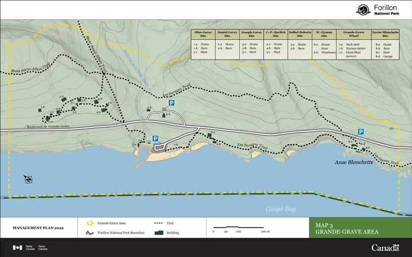
Map 3: Grande-Grave Management Area — Text version
This map details the Grande-Grave Management Area on the southwestern shore of Forillon National Park. Grande-Grave Management Area bisected by Boulevard de Grande-Grève (running east-west), there are three parking lots adjacent to this road. The following trails run through Grande-Grave Managment Area — Mont-Saint-Alban Trail, Les Parages Trail, and Les Graves Trail. The Grande-Grave Management Area contains eight sites and an assortment of building associated with each site, detailed in the table below:
Elias-Gavey Site
1-2 House
1-b Barn
1-c Shed
Daniel-Gavey Site
2-a House
2-b Barn
Joseph-Gavey Site
3-a House
3-b Barn
3-c Shed
C.-P.-Bartlett Site
4-a House
4-b Barn
4-c Shed
Dolbel-Roberts Site
5-a House
5-b Barn
W.-Hyman Site
6-a House-Store
6-b Warehouse
Grande-Grave Wharf
7-a Dock shed
7-b Kitchen shelter
7-c Kiosk-shed (partner)
Xavier-Blanchette Site
8-a House
8-b Barn
8-c Shed
8-d Garage
Area description
The Grande-Grave area is named after a former community that was established on the southern side of the Gaspé Peninsula before the park was created. It is a designated heritage site due to the number of heritage buildings still preserved to this day, in addition to the archaeological remains and landscapes that still bear witness to the area’s prior occupation hundreds of years ago. The local population and the park’s visitors have a strong sense of connection to this area, giving Forillon National Park a unique edge. The 2010 management plan called for the Grande-Grave area to be focused on as a prime area for the commemoration of the park’s former villages, as a way of recognizing the legacy left by the past occupants.
Since 2010, renovation work has been undertaken on the Blanchette site, the Joseph-Gavey house, and the Grande-Grave wharf, which required immediate attention to ensure their conservation. A study was also carried out in 2015 to better assess the value of Forillon National Park’s cultural resources and to eventually help with their conservation and promotion.
Main challenges and opportunities specific to the area
Many of the 17 buildings and accessory buildings that make up the Grande-Grave area were built in the late nineteenth century, and due to a lack of regular maintenance, many show undeniable signs of advanced deterioration. Despite the investments made in the past few years for some of them, it is urgent to act to preserve these heritage buildings, which bear witness to the families who lived in and shaped the area. The restoration of these buildings would also enable the park to develop a more authentic visitor experience.
Specific objectives for Grande-Grave area
Objective 7.1.1
The physical integrity of heritage buildings and structures is improved to conserve the heritage value.
Targets
Heritage buildings and structures used by visitors are in good condition and public access is ensured in the long term.
An intervention program is established by 2025 to confirm how the heritage buildings located in the Joseph-Gavey, Daniel-Gavey, Elias-Gavey and Charles-Bartlett sites will be used and to initiate their restoration.
Objective 7.1.2
The layout of the Grande-Grave area is redesigned and accessibility is improved to ensure a safe and quality experience for visitors.
Targets
A master plan is developed by 2024, taking into account the area’s carrying capacity.
Options are studied by 2026 to reduce the overcrowding of this area and to ensure safe access.
Specific Management Approach for Cap-Bon-Ami Area
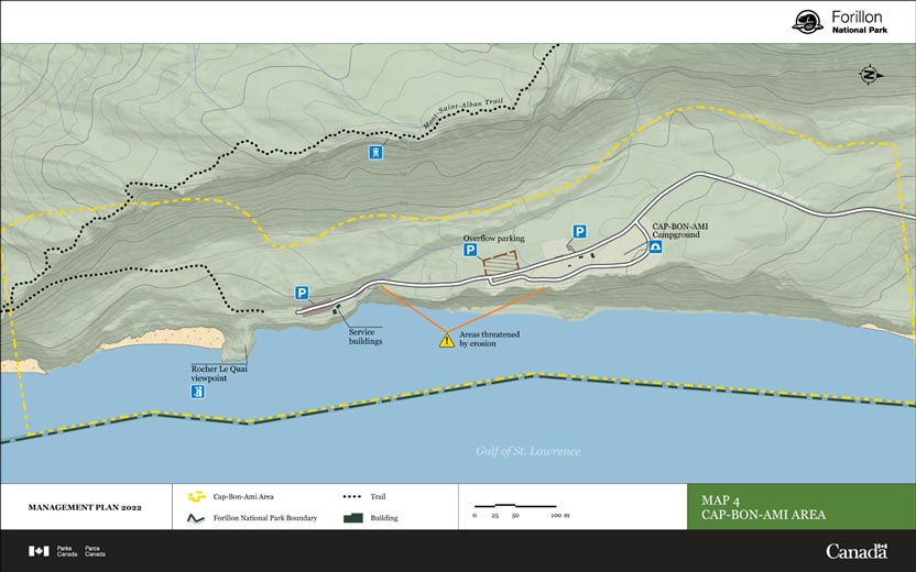
Map 4: Cap Bon Ami Management Area — Text version
This map details the Cap-Bon-Ami Management Area on the eastern shore of Forillon National Park. A road, the Chemin du Cap-Bon-Ami runs into the area from the north and terminates at a parking lot nearby two services buildings. There are two other parking areas and a campground adjacent to Chemin du Cap-Bon-Ami in the Cap-Bon-Ami Management Area. To the east of the road, between the campground and the road terminus, there are two areas that are indicated as being threated by erosion. The Cap-Bon-Ami Management Area also contains a segment of the Mont-Saint-Alban Trail and the Rocher Le Quai viewpoint.
Area description
With its maritime feel, towering cliffs and incredible points of view of the Gulf of St. Lawrence, the Cap-Bon-Ami area gives visitors to the park a true Gaspesian experience. Featuring a magnificent viewpoint where visitors can admire the surrounding landscape, it’s no wonder Cap-Bon-Ami is one of the park’s most iconic and popular areas. Activities in the area include bird-watching and marine wildlife observation, camping, hiking and relaxing on the beach. Since 2010, this area has also been home to the popular sunrise concert at the Festival Musique du Bout du Monde. Furthermore, in 2017, 2018 and 2019, a Mawiomi (a traditional Mi’gmaq celebration) has been held at Cap-Bon-Ami to celebrate International Day of the World’s Indigenous Peoples.
Main challenges and opportunities specific to the area
Today, the Cap-Bon-Ami area must contend with a major erosion phenomenon caused by climate change. Erosion threatens visitor services and infrastructure, including the access road to Cap-Bon-Ami and its campsite. Indeed, the number of campsites in Cap-Bon-Ami was reduced in 2011 when part of the cliff fell away.
What’s more, the popularity of special events held in this area has resulted in issues with traffic and parking. This situation calls for careful reflection about the harmonious cohabitation of these activities, the possible relocation of campsites, and the layout of the whole area as well as the access points, to make it safer, reduce congestion and ensure that visitors can continue to enjoy the area. This also provides the opportunity to consider alternative ways of reaching the area (on foot or by bicycle) and consequently to offer visitors more varied and more inclusive ways to experience this seaside area.
Specific objective for Cap-Bon-Ami area
Objective 7.2.1
The development of the area’s facilities (access road, parking, campsites) is reconsidered, taking into account the issue of coastal erosion, the unique character of the area, and the visitor experience.
Targets
By 2025, a risk and opportunity analysis related to the phenomenon of coastal erosion is completed.
A master plan for the entire area, including adaptive and mitigative measures for the risks related to coastal erosion, is developed by 2027. This master plan will present solutions for the challenges of accessing the Cap-Bon-Ami viewpoint, congestion in the area and parking, and the location of campsite facilities.
The propositions included in the master plan are implemented by 2032.
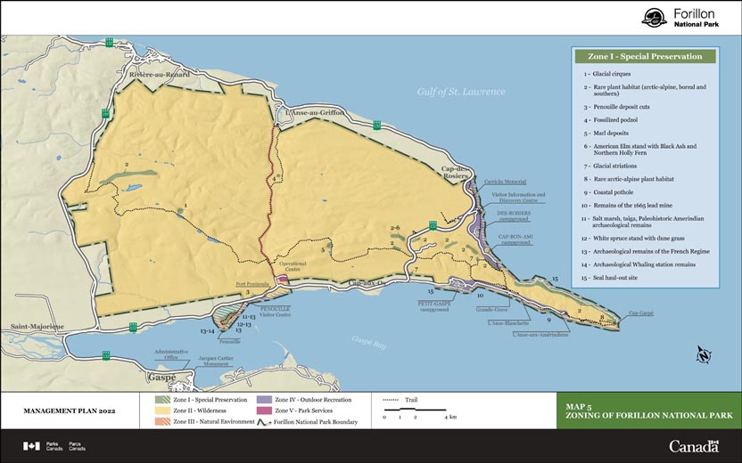
Zoning
Parks Canada’s national park zoning system is an integrated approach to the classification of land and water areas in a national park and designates where particular activities can occur on land or water based on the ability to support those uses. The zoning system has five categories:
Zone I – Special Preservation;
Zone II – Wilderness;
Zone III – Natural Environment;
Zone IV – Outdoor Recreation; and
Zone V – Park Services.
Forillon National Park’s zoning plan is presented in Map 5. Forillon’s zoning remains unchanged since the 2010 management plan, as thus far it has enabled the park to properly guide management decisions and the specific characteristics of each sector and protect each sector’s natural and cultural resources. It therefore corresponds to a suitable level of protection to maintain a balance between the preservation of the park’s ecosystems and the reception of visitors hoping to enjoy them.
Zone I – Special Preservation
Zone I – Special Preservation consists of several small areas totalling a surface area equivalent to 1.2 percent of the park’s entire area. These areas are home to exceptional, threatened, or at-risk natural or cultural features that warrant the highest levels of protection. The Zone I area of Forillon includes cliffs housing fragile arctic-alpine plants, rare in the province of Quebec, as well as geological and geomorphological formations that help shape the park’s landscape. Archaeological sites on the peninsula of the Penouille area, along with the taiga and salt marsh (essential areas for several species), are also included in Zone I.
Zone II – Wilderness
Zone II – Wilderness is spread out, covering most of the park (96.3 percent). Zone II offers a high degree of protection to the characteristic elements of the natural region it represents in order to preserve their wilderness state with minimal intervention.
Zone III – Natural Environment
Zone III – Natural Environment (0.7 percent of the park’s area) is made up of three linear areas, in addition to the narrow strip of marine area approximately 150 metres wide surrounding the terrestrial portion of the park. These three areas are an approximately five-kilometre-long corridor between Grande Grave and Cap-Gaspé, the access corridor to the Penouille peninsula beach and the beach itself, and an eight-kilometre-wide corridor in the area of the old Le Portage road.
Zone IV – Outdoor Recreation
Zone IV – Outdoor Recreation occupies approximately 1.8 percent of the park’s area and corresponds to areas developed for visitors: Cap-des-Rosiers, Trait Carré, Cap-Bon-Ami, Penouille, Fort Peninsula, Petit Gaspé and Grande-Grave. Automobile traffic corridors are also included in Zone IV.
Zone V – Park Services
Zone V – Park Services include the park’s operational centre, in the southernmost point of the Anse au Griffon Valley, the summit of the Cap-des-Rosiers Mountain (where telecommunications equipment is stored), and the road leading to it.
Map 5: Forillon National Park Zoning — Text version
This map details the zoning of Forillon National Park. The park is organized by the following zones:
Zone 1 — Special Preservation
Zone 1 consists of several small areas totalling a surface area equivalent to 1.2 percent of the park’s entire area mostly within the park interior and along the south eastern shore. These sites are indicated as follows:
Glacial cirques
Rare plan habitat (arctic-alpine, boreal and southern)
Penouille deposit cuts
Fossilized podzol
Marl deposits
American Elm stand with Black Ash and Northern Hollu Fern
Glacial striations
Rare arctic-alpine plant habitat
Coastal pothole
Remains of the 1665 lead mine
Salt marsh, taiga, Paleohistoric Amerindian archaeological remains
White spruce stand with dune grass
Archaeological remains of the French Regime
Archaeological Whaling station remains
Seal haul out site
Zone 2 — Wilderness
96.3 % of the park is organized under zone 2.
Zone 3 — Natural Environment
0.7% of the park is organized under zone 3, comprised largely of a narrow linear area running north-to-south and bisecting the park.
Zone 4 — Outdoor Recreation
1.8% of the park is organized under Outdoor Recreation. This zoning occurs largely at coastal areas on the southeastern and eastern shores of the park.
Zone 5 —Park Services
Park Services include the park’s operational centre, in the southernmost point of the Anse au Griffon Valley, the summit of the Cap-des-Rosiers Mountain (where telecommunications equipment is stored), and the road leading to it.
Summary of strategic environmental assessment
All national park management plans are assessed through a strategic environmental assessment to understand the potential for cumulative effects. This understanding contributes to evidence-based decision-making that supports ecological integrity being maintained or restored over the life of the plan. The strategic environmental assessment for the management plan for Forillon National Park considered the potential impacts of climate change, local and regional activities around the park, expected increase in visitation and proposals within the management plan. The strategic environmental assessment assessed the potential impacts on different aspects of the ecosystem, including the forest ecosystem, carnivorous animals, the evolution of coastal dynamics, and species at risk.
The forest ecosystem indicator is deemed to be in a poor condition with a declining trend according to the State of the Park Assessment (2018). The forests in Forillon National Park could suffer additional effects because of the increase in the moose population, which can alter the vegetation and significantly modify the forest dynamics. In addition, the emergence of a spruce budworm epidemic in recent years in Forillon National Park could lead to changes in forest composition. The target of the management plan is to have the moose population at a level that ensures ecosystem sustainability by 2032. To validate the state of the forest ecosystem, the strategic environmental assessment recommends updating the monitoring of forest stands and landscapes and continuing the monitoring of the exclosure system to accurately assess the impact of moose on the vegetation.
Carnivorous animals are also deemed to be in poor condition, and this is a stable trend according to the State of the Park Assessment (2018). The small size of Forillon National Park, in addition to the park’s peninsular location, limits the movement of certain animal populations between the park and the rest of the Gaspé Peninsula. Activities and developments outside the park have been shown to impact medium carnivores such as the American marten, the fisher, the red fox and the Canada lynx. Maintaining forest connectivity between the park and the greater ecosystem will limit the effect of habitat fragmentation for these species and the isolation of park populations. Strategies in the master plan include an update to the study of potential travel corridors for animal species. The strategic environmental assessment recommends continued collaboration and discussion with neighbouring stakeholders to increase management that encourages connectivity with the greater park ecosystem.
The evolution of coastal dynamics is deemed to be in fair condition with a declining trend, according to the State of the Park Assessment (2018). The sea-level rise will inevitably have repercussions on coastal dynamics at Forillon, especially in terms of coastal erosion and the potential submersion of coastal areas. In some lowland areas of the park, this could even lead to the loss or modification of important habitats. An objective of the management plan is to ensure that the latest information on climate change is used to guide park management and operations. Given that this environmental aspect is already well monitored and assessed in various projects, the strategic environmental assessment suggests following the recommendations resulting from these follow-ups when planning future developments within the context of climate change, and that restoration and infrastructure removal projects in coastal environments be continued.
The Micmac Nation of Gespeg, members of the Mi’gmaq communities, stakeholders and the public were provided with opportunities to provide comments on the draft plan and a summary of the draft strategic environmental assessment. Comments from the public, Indigenous groups and stakeholders were incorporated into the strategic environmental assessment and management plan as appropriate.
The strategic environmental assessment was conducted in accordance with the Cabinet Directive on the Environmental Assessment of Policy, Plan and Program Proposals (2010) and facilitated an evaluation of how the management plan contributed to the Federal Sustainable Development Strategy. Individual projects undertaken to implement management plan objectives at the site will be evaluated to determine if an impact assessment is required under the Impact Assessment Act, or successor legislation. The management plan supports the Federal Sustainable Development Strategy goals of connecting Canadians to nature, healthy wildlife populations and sustainably managed lands and forests. Many positive environmental effects are expected and there are no important negative environmental effects anticipated from implementation of the Forillon National Park of Canada Management Plan.
Contact us
For more information about the management plan or about Forillon National Park of Canada:
Forillon National Park of Canada 1501 Forillon Boulevard
Gaspé QC G4X 6M1
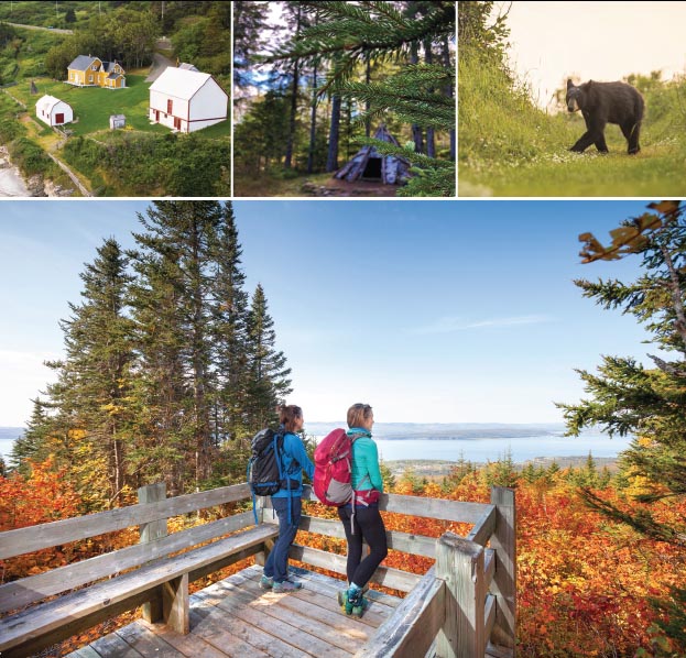
Front cover image credits
top from left to right: Parks Canada/L. Barnes; Micmac interpretation Site of Gespeg/F. Langlois; Parks Canada/M. Dupuis
bottom: Parks Canada/F. St-Laurent
PDF: R64-105/84-2002E-PDF 978-0-660-41628-1
Paper: R64-105/15-2022E 978-0-660-41627-4
Cette publication est aussi disponible en français.