
Lake Superior National Marine Conservation Area interim management plan 2016
Lake Superior National Marine Conservation Area
Table of Contents
- Foreword
- Recommendations
- Interim Management Advisory Board Members
- The Parks Canada Vision
- The Parks Canada Charter
- 1.0 Introduction
- 2.0 Interim Planning Context
- 3.0 A Vision for the Lake Superior NMCA
- 4.0 Management Strategies and Actions
- 5.0 Area Concepts
- 6.0 Zoning
- 7.0 Monitoring and Reporting
- 8.0 Summary of Strategic Environmental Assessment
List of Appendices
- Appendix A – Interim Management Advisory Board Recommendations Supplementary to this Interim Management Plan
- Appendix B – Interim Management Advisory Board Suggested Interim Research Needs
- Appendix C – Interim Management Plan Development Path
- Appendix D – Other Protected Natural Heritage Areas in the Region (Canadian)
- Appendix E – Interim Management Advisory Board Vote Results by Member


© Her Majesty the Queen in Right of Canada, represented by the Chief Executive Officer of Parks Canada, 2016.
Cette publication est aussi disponible en français.
National Library of Canada cataloguing in publication data:
- Parks Canada
- Lake Superior National Marine Conservation Area Interim Management Plan
Issued also in French under the title:
Plan directeur provisoire de l’Aire marine nationale de conservation du Lac-Supérieur
Available also on the Internet.
- ISBN: R64-344-2015E
- Cat. no. 978-0-660-03581-9
For more information about the management plan or about Lake Superior National Marine Conservation Area of Canada
22 Third Street
P.O. Box 998
Nipigon, Ontario, Canada
P0T 2J0
Front cover image credits
top from left to right: Rob Stimpson, Dale Wilson and Dale Wilson
bottom: Dale Wilson
Foreword

Canada's national parks, national historic sites and national marine conservation areas belong to all Canadians and offer truly Canadian experiences.
These special places make up one of the finest and most extensive systems of protected natural and cultural heritage areas in the world.
The Government is committed to conserving and presenting our national marine conservation areas, expanding the system of protected places and contributing to the recovery of species-at-risk. At the same time, we must continue to develop new and innovative programs and services to allow more Canadians to experience and learn about our environment and history.
This new interim management plan for Lake Superior National Marine Conservation Area of Canada supports this vision.
This interim management plan was developed through extensive consultation and input from various people and organizations, including Indigenous Peoples, local and regional residents, visitors and the dedicated team at Parks Canada.
National parks, national historic sites and national marine conservation areas are a priority for the Government of Canada. I would like to thank everyone who contributed to this plan for their commitment and spirit of co-operation.
As the Minister responsible for Parks Canada, I applaud this collaborative effort and I am pleased to approve the Lake Superior National Marine Conservation Area of Canada Interim Management Plan.
Recommendations
Recommended by:
Daniel Watson
Chief Executive Officer
Parks Canada
Robin Lessard
Field Unit Superintendent
Northern Ontario Field Unit
Parks Canada
Kevin McNamee
Director, Protected Area Establishment
Protected Areas Establishment and Conservation Directorate
Parks Canada
Interim Management Advisory Board Members
Please note: Appendix E includes Interim Management Advisory Board vote results by member.
The Parks Canada Vision
Canada's treasured natural and historic places will be a living legacy, connecting hearts and minds to a stronger, deeper understanding of the very essence of Canada.
The Parks Canada Charter
Our Mandate
On behalf of the people of Canada, we protect and present nationally significant examples of Canada’s natural and cultural heritage, and foster public understanding, appreciation and enjoyment in ways that ensure their ecological and commemorative integrity for present and future generations.
Our Role
- We are guardians of the national parks, the national historic sites and the national marine conservation areas of Canada.
- We are guides to visitors the world over, opening doors to places of discovery and learning, reflection and recreation.
- We are partners, building on the rich traditions of our First Nations and Métis people, the strength of our diverse cultures and our commitments to the international community.
- We are storytellers, recounting the history of our land and our people — the stories of Canada.
Our Commitments
- To protect, as a first priority, the natural and cultural heritage of our special places and ensure that they remain healthy and whole.
- To present the beauty and significance of our natural world and to chronicle the human determination and ingenuity which have shaped our nation.
- To celebrate the legacy of visionary Canadians whose passion and knowledge have inspired the character and values of our country.
- To serve Canadians, working together to achieve excellence guided by values of competence, respect and fairness.
1.0 Introduction
“Those that have never seen Superior get an inadequate, even inaccurate idea, by hearing of it spoken of as a ‘lake’, and to those who have sailed over its vast extent the words sound ludicrous. Though the waters are fresh and crystal, Superior is a sea. It is cold in mid-summer as the Atlantic. It is wild, masterful...”
The Lake Superior National Marine Conservation Area of Canada is the largest freshwater
protected area in the world. In “flat calm” sailing conditions, motorized travel time from
Terrace Bay at the eastern end of the NMCA to Silver Islet in the west can be seven and a
half hours. Vessels experiencing three foot swells during this crossing may need to plan
for a trip of double the time. This dramatic setting of untamed water, rugged coast and
vast natural resources has shaped human use and settlement for millennia, and is now
formally recognized through Parks Canada’s stewardship of Canada’s first national
marine conservation area.
Parks Canada works to foster Canadians’ sense of connection to their national marine conservation areas, national parks and national historic sites and by holding in trust a world-renowned system of heritage areas for the enjoyment of all. By establishing marine conservation areas such as the Lake Superior National Marine Conservation Area (NMCA), new places are protected and conserved, additional opportunities are created for Canadians to connect with these places, and Parks Canada expands its reach in facilitating meaningful experiences, public appreciation and understanding. The management and ecologically sustainable use of this vast area will ensure its conservation for the enjoyment and appreciation of present and future generations of Canadians.
In collaboration with First Nations and Métis organizations, provincial government representatives, other federal agencies, coastal communities and other organizations, Parks Canada produces an interim management plan as the initial document to guide the management and administration of a national marine conservation area. An interim management plan is forward looking in outlook, strategic in scope, and is intended to guide the NMCA’s management during the first five years following establishment. It serves as the chief accountability document for the people of Canada. Within five years of NMCA establishment, the interim management plan is replaced with a management plan that updates the vision, actions, and management direction to reflect knowledge and experience gained over this period.
1.1 Legislative Basis for Interim Management Planning
The Canada National Marine Conservation Areas Act (2002), (CNMCA Act)
administered by the Parks Canada Agency, provides the authority to establish national
marine conservation areas. The objectives of the legislation include protecting and
conserving marine areas that represent Canada’s ocean and Great Lakes environments.
Specifically, under Section 4(1) of the Act, “Marine conservation areas are established in
accordance with this Act for the purpose of protecting and conserving representative
marine areas for the benefit, education and enjoyment of the people of Canada and the
world.”
The concept of ecologically sustainable use guides the management of national marine conservation areas as stated under Section 4(3) of the Act, “Marine conservation areas shall be managed and used in a sustainable manner that meets the needs of present and future generations without compromising the structure and function of the ecosystems, including the submerged lands and water column, with which they are associated.” Ecologically sustainable use is further reinforced under Section 4(4) of the Act which requires that each NMCA include one zone that fosters and encourages ecologically sustainable use of marine resources. The CNMCA Act also prohibits waste dumping, mining, and oil and gas exploration and development. The passing of Bill C-61, An Act to amend the Canada National Marine Conservation Areas Act on June 23, 2015, confirmed the legal description of the lands and lake bed that Ontario will transfer to Canada upon the completion of several administrative processes now underway. Once legally established, the Lake Superior NMCA will represent a major contribution towards achieving commitments identified in the CNMCA Act and the Federal Marine Protected Areas Strategy (2005) which serves to guide and coordinate efforts of federal agencies in establishing marine protected areas.
1.2 Parks Canada’s Mandate
On behalf of the people of Canada, we protect and present nationally significant examples of Canada’s natural and cultural heritage, and foster public understanding, appreciation and enjoyment in ways that ensure the ecological and commemorative integrity of these places for present and future generations.
The strategic outcome of Parks Canada’s mandate is that
“Canadians have a strong sense of connection, through meaningful experiences, to their national parks, national historic sites and national marine conservation areas and these protected places are enjoyed in ways that leave them unimpaired for present and future generations.”
Parks Canada’s mandate embraces three mutually supportive program areas that are delivered in an integrated manner. These include:
Protecting heritage resources
- by ensuring natural and cultural resources in Parks Canada’s protected heritage places are protected for Canadians;
Fostering public appreciation and understanding
- by connecting with Canadians from all walks of life in diverse, meaningful ways to increase awareness, understanding, and appreciation of the significance of Canada’s protected heritage places and why they should be protected and presented; and,
Facilitating meaningful visitor experiences
- by supporting the sum total of a visitor’s personal interaction with a protected heritage place to facilitate an interaction that awakens the senses, affects the emotions, stimulates the mind, and helps the visitor create a sense of attachment and connection to these places.
The establishment of the Lake Superior NMCA contributes to the environmental, social, and economic health of Canadians, today and tomorrow. It supports regional economic development and the well-being of coastal communities, through opportunities for visitor experience, public outreach education, and long-term meaningful involvement in the place’s planning and management. This relevance enriches Canadians’ appreciation of, pride for, and personal connection to their country and the special places within it.
Once established, the Lake Superior NMCA will represent the Lake Superior Natural Marine Region; one of 29 marine regions within Canada’s Pacific, Arctic, Atlantic and Great Lakes marine ecosystems.
1.3 The Road to Establishment
The northern Lake Superior region has been of conservation interest for decades. In 1993, Parks Canada conducted a regional analysis of the Lake Superior Natural Marine Region and in 1995 selected an NMCA candidate area that would fully represent the marine region. In 1997, the governments of Canada and Ontario signed a Memorandum of Understanding to launch a feasibility assessment and in 1998, the Regional Committee was established to develop a concept and to provide advice on the project. After extensive public consultation, the Regional Committee recommended that the federal government proceed with the establishment of a national marine conservation area based on strong public support. This recommendation was subsequently supported by a review of the feasibility assessment process by the Independent Review Committee.
In 2006, Parks Canada and the Northern Superior First Nations signed a Protocol Agreement (Protocol for the Development of Shared Understandings Between the Parks Canada Agency and Northern Superior Chiefs with respect to the Proposed National Marine Conservation Area in Western Lake Superior) with the objective of reaching shared understandings related to the future NMCA. In 2007, Canada and Ontario signed an agreement (Memorandum of Agreement Respecting the Establishment of a National Marine Conservation Area of Canada in Lake Superior) to establish a national marine conservation area in Lake Superior. Later that same year the federal government and the Northern Superior First Nations signed a Memorandum of Understanding committing both parties to achieve the objectives of the 2006 Protocol Agreement.
In 2008, the federal Minister of the Environment appointed a 20-member, multi-interest Interim Management Advisory Board (the Board) to advise Parks Canada and its partners on the interim management planning process. The Board was comprised of representatives of local First Nations, coastal communities adjacent to the Lake Superior NMCA, non-governmental organizations, academia, and two “at large” members. Since its inception, the Board was mandated with “representing the needs and interests of all communities and ecosystems and building relationships to communicate the interim management plan to communities and other interested parties.” The Board contributed greatly to the development of this interim management plan and in carrying out its mandate, also formulated supplemental recommendations (Appendix A), and suggested a number of interim research needs (Appendix B).
Completion of this interim management plan is an important step toward the establishment of the Lake Superior NMCA but more work remains. Continuing dialogue with representatives of the Northern Superior First Nations and discussions with Ontario and other federal agencies will contribute to future management directions. Completion of the legal boundary survey in 2013 and the passing of Bill C-61 were necessary precursors to enabling Ontario to initiate the administrative work required to facilitate the transfer of islands and lakebed from Ontario to Canada.
1.4 Purpose of this Interim Management Plan
This interim management plan provides strategic direction, including a vision, supporting area concepts, management strategies, and actions to guide work priorities towards the development of a comprehensive management plan for the marine area within five years of establishment. It constitutes a commitment to Canadians regarding the protection, ecologically sustainable use, enjoyment, and appreciation of the Lake Superior NMCA. In 2009, the Board, in collaboration with Parks Canada, drafted six management objectives to assist in achieving the vision and to help guide the development of this interim management plan. These objectives have formed the basis for the evolution of the area concepts, management strategies and actions and zoning plan which follow. The development of this interim management plan from the 2009 management objectives is further illustrated for clarity in Appendix C. The management objectives which underpinned the development of this interim management plan include the following:
- Maintain meaningful community relationships;
- Build an NMCA community;
- Showcase the NMCA;
- Facilitate the Lake Superior experience;
- Honour the past; and
- Protect and sustain.
This interim management plan provides the framework for decision-making and how Parks Canada will work with First Nations and Métis organizations, partners (an organization that is in a working relationship with Parks Canada) and stakeholders (a person or organization with an interest in the Lake Superior NMCA) to manage the NMCA in the coming years. It will also help guide the development of business plans and work plans in the Northern Ontario Field Unit. Some actions may be completed prior to the preparation of the first Lake Superior NMCA management plan (within five years of establishment) whereas others may be initiated but take longer to complete or are ongoing in nature.
1.5 The Role and Contributions of First Nations
The Government of Canada has a unique relationship with First Nations peoples, as affirmed in Section 35 of the Constitution Act (1982). The depth and importance of this relationship is such that significant efforts to recognize and respond to First Nations concerns have assisted the development of this interim management plan.
The 2006 Protocol for the Development of Shared Understandings Between the Parks Canada Agency and Northern Superior Chiefs as well as the 2007 Memorandum of Understanding have provided context for the strategies and actions in this interim management plan. These documents will continue to inform decisions regarding First Nations matters leading to the completion of a future protocol report agreement as required by the 2006 Protocol.
The protocol report agreement (Agreement Between The Parks Canada Agency And The Northern Superior First Nations Regarding Lake Superior National Marine Conservation Area of Canada) which will be completed by Parks Canada and the participating Northern Superior First Nations will identify shared understandings with respect to the following items:
- The nature and extent of First Nations participation in the planning and management of the Lake Superior National Marine Conservation Area, including financial support for such participation;
- The provision of direct and indirect benefits to First Nations including:
- employment with Parks Canada;
- training of First Nations people to obtain the skills required for ongoing employment within the Lake Superior NMCA;
- partnership opportunities that provide economic benefits; and
- identification of economic development opportunities that may be available within the Lake Superior NMCA;
- The protection, management and heritage presentation of First Nations cultural and spiritual sites within the Lake Superior National Marine Conservation Area; and
- Any consultation plan required to address any duty of consultation that the Parks Canada Agency or the Government of Canada may have toward the First Nations of the Northern Superior region.
2.0 Interim Planning Context
“Unless the hearts and minds of the local people are on the side of conservation, there is no hope that a protected area can achieve its purpose.”
Lake Superior is an international water body administered by the governments of Canada and the United States, the Province of Ontario, and the states of Minnesota, Wisconsin and Michigan. Many departments and agencies are responsible for managing the health of the lake and promoting its enjoyment. As a key custodian of protected heritage places within the Lake Superior watershed, Parks Canada plays an important role in enhancing the lake’s protection, stewardship, visitor enjoyment, and public appreciation.
Lake Superior is also vital to the livelihood of coastal communities, First Nations and tribal governments in the U.S., Métis peoples, industry, global shipping, nongovernmental organizations, and citizens groups. The region within and around the Lake Superior NMCA is sparsely populated and much beloved by residents and visitors alike. As the NMCA is governed under complex jurisdictional arrangements, successful management will require stakeholders and partners to continuously share information, develop harmonious objectives, and implement complementary projects.
2.1 Collaboration and Shared Responsibility
The governments of Canada and the United States have long recognized the challenges of administering a shared border that includes many rivers and some of the largest freshwater lakes in the world. Acknowledging that each country’s actions can affect the other, the two governments signed the Boundary Waters Treaty in 1909 which established the International Joint Commission (IJC). The IJC works to prevent and/or address disputes and to foster bilateral management of the Great Lakes.
The signing of the Federal–Provincial Memorandum of Agreement Respecting the Establishment of a National Marine Conservation Area of Canada in Lake Superior in 2007 reinforced the concept of inter-governmental cooperation on the Canadian side of the lake, and affirmed the need for a collaborative management model for the Lake Superior NMCA. With authority under Section 11.1 of the Federal-Provincial Memorandum of Agreement, the Federal–Provincial Harmonization Committee established in November, 2010 serves as a “steering committee” for jurisdictional matters relating to fisheries and fish habitat, wildlife harvesting, joint resource management, environmental impact assessments, marine navigation and safety, research, and cultural resources management within the NMCA. The Harmonization Committee may also address inter-jurisdictional matters relating to the establishment and ongoing management of the Lake Superior NMCA, including Parks Canada’s future responsibilities in activities such as development regulation (e.g., construction of docks), ecosystem management, and regulatory enforcement.
Traditional fishing, hunting, and other renewable resource extraction activities are permitted within the Lake Superior NMCA. These activities are to be managed to protect natural, self-regulating ecosystems and to maintain biological diversity. In the context of this interim management plan, the Ontario Ministry of Natural Resources will continue to regulate activities such as recreational and commercial fishing, hunting, and trapping while Fisheries and Oceans Canada will continue to manage fish habitat programs. Parks Canada may play a lead and/or partnering role in fish habitat management, research and monitoring after the Lake Superior NMCA is established to assist in the protection of resources and to ensure ecosystem health. In so doing, Parks Canada would work with the Ontario Ministry of Natural Resources and Fisheries and Oceans Canada. For clarity, as stated under Section 9(4) of the CNMCA Act.
“Provisions of a management plan or an interim management plan respecting fishing, aquaculture and fisheries management are subject to an agreement between the Minister [of the Environment]and the Minister of Fisheries and Oceans.”
2.2 Geophysical Context
Lake Superior is the world’s largest freshwater lake by surface area and the third largest lake by volume after Lake Baikal in the Russian Federation and Lake Tanganyika in eastern Africa. It has an average depth of 147 metres with a maximum depth of 406 metres although dramatic changes can occur over relatively short distances in some areas. The best example of this phenomenon within the NMCA is the geographic feature that creates Superior Shoals, which is in fact an undersea “mountain” where depths of less than 10 metres can suddenly drop to hundreds of metres.
The Lake Superior NMCA encompasses the north part of Lake Superior, extending from Bottle Point near Terrace Bay in the east to Thunder Cape at the tip of Sibley Peninsula in the west, and from the shoreline in the north to the Canada-United States border in the south. Approximately 10,880 km2 in size, theNMCA occupies approximately one eighth of Lake Superior and one third of the Canadian side of the lake. It also surrounds, or is adjacent to, a number of other protected areas (see Appendix D) distributed across two large peninsulas and an archipelago of isolated islands of varying sizes and characteristics. The Lake Superior NMCA includes approximately 60 km2 of dry land encompassing smaller islands inextricably linked with the lake environment and places with high natural and/or cultural heritage value. Included are all islands 100 hectares and less (excluding private landholdings) and nine islands larger than 100 hectares. Four mainland sites extend protection to cultural sites.
Figure 1: Location Map

Location Map - Text Version
Map showing the location of Lake Superior National Marine Conservation Area of Canada. Locations include:
- Fort William First Nation
- Thunder Bay
- Dorion/Hurkett
- Red Rock
- Lake Helen
- Nipigon
- Pays Plat
- Rossport
- Schreiber
- Terrace Bay
- Marathon
- Pukaskwa National Park
- Wawa
- Sault Ste Marie
More than 200 tributaries drain into Lake Superior from a relatively small (by lake surface area) watershed. The large volume of the lake (12,100 km3) and relatively small discharge account for a water residence time of approximately 191 years making the lake particularly sensitive to pollutants. Nipigon Bay and Black Bay are large, shallow, warm, and highly productive environments unique to the western portion of the lake. They provide important habitat for many fish species that are not typically found at greater depths and attract recreational and commercial fishing. Offshore shoals and associated currents and upwellings near the outer islands also make these areas attractive for fishing.
During the Wisconsin glacial period 10,000 years ago, ice covered Lake Superior to a thickness of approximately 3,200 metres. With the last major glacial retreat, debris formations known as moraines remained covering the underlying bedrock. The tremendous weight of the glacial ice compressed the underlying rock strata but once released, the earth slowly rebounded. The result of this isostatic rebound is seen today in sometimes dramatically terraced landscapes on both the mainland coast and some islands. The region also features unique geological formations such as columnar basalt outcroppings, geodes, and stromatolites (fossilized blue-green algae which are major constituents of the fossil record from the earliest periods of life on earth). Some of the world's oldest known rocks, about 2.7 billion years old, can be found on the Ontario shore of Lake Superior both within and adjacent to the Lake Superior NMCA.
2.3 Biological Context
The Lake Superior NMCA protects species, ecosystems, aquatic processes, and biological diversity representing the Lake Superior Natural Marine Region. Despite having a very low dissolved nutrient content (oligotrophic) the lake supports seventy species of primarily cold water fish representing a mix of: native (e.g., Lake Trout, Lake Sturgeon, Siscowet Trout, Lake Whitefish); introduced (e.g., Chinook Salmon, Rainbow Trout); and invasive (e.g., Sea Lamprey) species. Water birds such as Herring Gulls, Double-crested Cormorants, Great Blue Herons and American White Pelicans are found throughout the NMCA and raptors such as Bald Eagles and Peregrine Falcons nest along the coast. Black bear, otter, deer, moose, wolf, lynx, and smaller mammals populate the mainland and are known to occupy some islands and peninsulas both permanently and seasonally. Disjunct and rare arctic-alpine plant communities, products of lake microclimates, occur on exposed shorelines with warmer sandy beaches providing habitat for more southern plant species in scattered locations. The arrival of spring and autumn in Lake Superior signal exciting times for bird watchers and outdoor enthusiasts as thousands of fish return to the rivers to spawn and large birds of prey congregate nearby to take advantage of the annual fish migrations. Several Species at Risk (SAR) have also been known to frequent the Lake Superior NMCA including a number of fish species and the monarch butterfly.
2.4 Cultural and Historical Context
The land, waters and resources encompassed by the Lake Superior NMCA have supported First Nations for thousands of years. This relationship continues to the present day. Over the past centuries, successive waves of exploration and development have involved the fur trade, mineral and forestry exploitation, commercial fishing, and shipping, to name a few activities. Today, the living cultural heritage of the First Nations, Métis, and Euro- Canadians such as the descendants of Finnish immigrants forms one of the most distinguishing characteristics of the Lake Superior NMCA.
Seventy archaeological sites are known to exist within the Lake Superior NMCA; 28 of these are located on lands to be administered by Parks Canada. These sites vary from pictographs, to grave sites, campsites, shipwrecks, and other structures and resources. In terms of cultural affiliation, 55% of the known sites are First Nation, 23% Euro-Canadian, and 8% jointly First Nation and Euro-Canadian. The remaining sites have not yet been assessed. A preliminary archaeological survey completed in 2010 catalogued 35 sites as pre-European.
2.5 Tourism and Socio-Economic Overview
The Lake Superior NMCA enjoys a central location and is accessible to both eastern and western Canadian markets as well as the American upper Midwest. The city of Thunder Bay offers a growing market of 123,000 residents within a short drive of the NMCA. Duluth, Minnesota, a four hour’s drive from the western boundary of the NMCA, has a metropolitan population of 115,000. Winnipeg, Manitoba; Toronto, Ontario; and Minneapolis, Minnesota represent a combined market of nearly 9.6 million people, at driving distances of approximately nine, sixteen and seven hours respectively.
The Trans-Canada Highway provides both access to and a dramatic coastal experience along the NMCA; in 2007 (the latest date for which information is available), average daily traffic volumes ranged from 1,700 to 3,600 vehicles between Terrace Bay and the intersection with Highway 11 at Nipigon, and up to 5,500 farther west towards the Highway 587 entrance to Sleeping Giant Provincial Park. Summer daily volumes exceed these figures by about 30 percent. Several towns dot the Lake Superior shoreline along the Trans-Canada Highway abutting the NMCA, including Nipigon, Dorion/Hurkett, the Township of Red Rock, Schreiber, Silver Islet, Rossport, and Terrace Bay, along with the First Nation communities of Red Rock Indian Band and Pays Plat. Thunder Bay International Airport, the third busiest airport in Ontario by both passenger service and freight volumes, provides efficient, long-distance access to the region.
The economy of northern Ontario has traditionally been rooted in mining and forestry, with some manufacturing. Thunder Bay has a more service-based economy led by business services, health and social services, and retail trade. Post-secondary educational institutions in Thunder Bay such as Lakehead University and Confederation College are also a regional draw for students. Full-time median earnings in 2005 within the Thunder Bay census metropolitan area (CMA) for those 15 years of age and over was just slightly below the provincial median of almost $45,000. The 2006 census data reveals that nearly 15% of Thunder Bay CMA residents possess a university certificate, diploma or degree.
The report Tourism in Northern Ontario, An Overview commissioned by FedNor (a federal regional development organization) in 2009 revealed that in 2007, visitors to northern Ontario spent $1.4 billion, generated $924 million in economic activity during 7.7 million overnight or same-day trips, and supported 16,000 jobs. Although the Toronto CMA was the single largest market for northern Ontario during 2007, nearly 800,000 overnight pleasure tourists were Americans, of which nearly two-thirds visited northwest Ontario. American visitors can be particularly important to local economies as they typically stay longer than Canadian travelers and spend more than twice as much in the region. Three-fifths of overnight visitors to northern Ontario in 2007 took part in outdoor activities. In order of popularity, the top five activities were fishing, boating/canoeing/kayaking, camping/nights in a campground/RV park, visiting a national or provincial nature park, and visiting an historic site.
In terms of national and provincial parks in the region, annual attendance at Pukaskwa National Park (approximately 90 km from the eastern edge of the NMCA) averaged around 7,000 visits between 2005 and 2010 while Sleeping Giant Provincial Park registered 57,700 visitors in 2008. The differing visitation levels may be related to the proximity of the latter park to the city of Thunder Bay and its appeal to a more diverse, family-oriented audience, as opposed to the more remote location and wilderness experience offered by Pukaskwa.
As a definition of a visitor to an NMCA is currently unavailable, an attendance program cannot yet be developed. The 2006 Parks Canada Visitor Information Program survey for Pukaskwa however, revealed 59% of surveyed visitors came from Ontario, 27% from the USA, 5% from Quebec, and 7% from the rest of Canada. First time visitors accounted for 58% of park visitation and the average party size was 2.4. These and other statistics may offer a starting point for determining potential visitation within the Lake Superior NMCA and form a basis from which it can increase its contribution to regional economic development.
3.0 A Vision for the Lake Superior NMCA
A vision describes a desired but continuously evolving future to which Parks Canada and its partners will strive and against which progress towards its achievement will be measured. The vision for the Lake Superior NMCA described below reflects the shared perspective of Parks Canada, the Board, First Nations, and the public on the desired character, experiences, and cooperation that will make the NMCA a vibrant, healthy, and important place for all Canadians.
“To respect our natural and cultural heritage by balancing preservation,
responsible use and enjoyment by all, for present and future generations.”
People have envisioned:
“That the wondrous natural features of the archipelago, the strength and beauty of its seascape, the diversity and uniqueness of its plant and animal life, and its wildness be protected and maintained.”
“That the cultural and spiritual places of the First Nations people be respected, and that traditional knowledge and Aboriginal history be incorporated into the management of the area.”
“That the history of the area be told and that its lighthouses, shipwrecks and other cultural sites be preserved.”
“That current industrial use of the north shore not be impaired by the National Marine Conservation Area, that commercial and sport fishing, hunting and trapping continue to be sustained and that private property rights be respected.”
“That traditional activities continue and that the National Marine Conservation Area provide the mechanism to manage the nature, location and impacts of future use of the area.”
“That an extensive partnership emerges to achieve conservation objectives and realize economic and tourism benefits for the area.”
“That a meaningful and responsible role be given to local citizens to provide direction and recommend priorities for the area.”
“That through personal experiences people connect with what makes the Lake Superior National Marine Conservation Area meaningful in each of their lives, and that the spirit of the place find itself in the hearts and minds of all, invoking a stronger, deeper understanding of the very essence of Canada.”
The basis for the above vision was presented in the document A Superior Vision: A National Marine Conservation Area for a Great Lake (Parks Canada, 2002), which was subject to community consultation. That vision was updated in 2010 to take its current form, was verified by public consultations, and was strongly supported by the Board. As illustrated above, it remains essentially unchanged today from the 2002 version.
4.0 Management Strategies and Actions
"We turn our minds to you, the various bodies of water. The rivers, the lakes, the oceans and the springs. You fulfill a vital function in the continuation of the cycle of life. You provide us with the most powerful medicine there is, for water has the ability to give and to sustain life."
Parks Canada, in collaboration with the Board, has drafted five management strategies with associated actions to help achieve the NMCA vision. Whereas the vision described in Section 3 describes the “what,” these management strategies describe the “how.” While actions under the area concepts illustrate basic physical and organizational opportunities, these strategies and associated actions address larger goals relating to conservation, public appreciation and understanding, public outreach education, and visitor experience in an integrated, mutually-supportive manner. They are accompanied by supporting statements crafted by the Board which appear in italics.
Conserving a Sweetwater Sea
“We value Lake Superior’s remoteness and relatively pristine character and recognize the significant natural and cultural components that make it unique.” Discovering and Connecting with the Superior Legacy “We wish visitors the opportunity to experience the natural beauty, majesty and serenity of Lake Superior and to gain an appreciation of the magnitude, power and fury of this seemingly endless freshwater sea.”
Enriching Understanding of Past and Present
“We will honour both the natural and human history of the area by involving and celebrating the people and communities of the present.”
Promoting Shared Stewardship
“As stewardship partners, we have a real, relevant and meaningful community relationship built upon transparency, accountability and trust.”
Reaching out from Local Communities to the World
“With coastal communities and First Nations as a foundation for the future, education and outreach will enhance world-wide awareness of, and appreciation for, the value of Lake Superior’s wild shores.”
4.1 Conserving a Sweetwater Sea
“We value Lake Superior’s remoteness and relatively pristine character and recognize the significant natural and cultural components that make it unique.”
This strategy advances Parks Canada’s heritage protection in support of transformative visitor experiences that facilitate inspired discovery, enjoyment, and personal connections to the Lake Superior NMCA. Within the context of ecologically sustainable use, this strategy will be successful when important natural and cultural resources are protected and conserved for the environmental, social, and economic benefit of Canadians.
In support of this strategy, Parks Canada will undertake the following actions:
- Update the digital inventory of ecological and cultural features (including submerged heritage resources), using other government and local knowledge wherever possible and encouraging visitor participation;
- Collaborate with partners and stakeholders in using secondary data and indigenous knowledge to explore the development of a suite of ecosystem and cultural site objectives and indicators that reflect principles of ecologically sustainable use;
- Work with Environment Canada, Fisheries and Oceans Canada, the Ontario Ministry of Natural Resources, and local knowledge sources to assess the state of Species at Risk related information as a basis on which to develop SAR strategies;
- Utilize a visitor-centred approach to identifying opportunities for the promotion of the ecologically sustainable use of NMCA resources with an emphasis on engaging youth through public outreach education;
- Develop and initiate strategies to identify and protect natural and cultural resources with the participation and assistance of visitors, partners and stakeholders where possible;
- In conjunction with partners and stakeholders, implement and monitor the zoning presented in Section 6 of this plan and develop communication tools to educate the public about Parks Canada zoning in marine areas;
- Encourage the participation of youth, visitors, partners and stakeholders in the conservation, monitoring and management of the NMCA’s natural and cultural resources;
- Work with educational institutions to explore learning opportunities within the NMCA and begin developing research and conservation partnering arrangements; and
- In conjunction with other government bodies, U.S. National Park Service staff at Isle Royale National Park, and regional stakeholders, investigate opportunities to cooperate in ecosystem policy and management, and address threats posed by aquatic invasive species.
4.2 Discovering and Connecting with the “Superior”
Legacy
“We wish visitors the opportunity to experience the natural beauty, majesty and serenity of Lake Superior and to gain an appreciation of the magnitude, power and fury of this seemingly endless freshwater sea.”
The Lake Superior NMCA offers unique and authentic opportunities for visitors to experience the largest lake in the Western Hemisphere, the majesty of a wild inland sea, uninhabited islands, local First Nations, Métis and other cultures. Visitors can immerse themselves in a dramatic setting that in many ways remains similar to that which First Nations, Métis and the voyageurs of two centuries ago experienced in their countless crossings of the lake. This strategy will be successful when visitors explore, discover, and learn within this unique complex of marine and terrestrial environments in ways that are meaningful to them.
In support of this strategy, Parks Canada will undertake the following actions:
- Use secondary social science data to better understand market needs and to identify potential trends and targets markets in cooperation with partners and stakeholders;
- Develop visitor experience opportunities, products, and services based on social science information as well as natural and cultural resource data that respond to market needs and trends;
- Explore ways to engage, support, and work collaboratively with volunteers and
volunteer organizations to bring the
“Superior experience”
to visitors; - Explore options for engaging youth and senior citizens through new media and Web-based tools to enrich public outreach education opportunities;
- Adapt the Parks Canada NMCA visitor attendance and monitoring framework (once it is in place) to a visitor and attendance monitoring program that supports Parks Canada’s reporting, visitor experience concept development, and its collaboration with partners and stakeholders.
- Begin to identify prospects for collaboration in ecologically sustainable use opportunities and the facilitation of visitor experiences in cooperation with First Nations and Métis organizations, coastal communities, the tourism industry, and other government bodies; and
- Work with First Nations and Métis organizations to explore ways to introduce visitors to First Nations and Métis culture and history.
4.3 Enriching Understanding of Past and Present
“We will honour both the natural and human history of the area by involving and celebrating the people and communities of the present.”
This strategy guides Parks Canada’s work with First Nations, Métis organizations, and coastal communities with respect to cultural and natural resources. The strategy’s overall intent is to protect and present these resources, to enhance on and off-site audiences' awareness and appreciation of them, and to encourage community participation in management of these resources in a manner that is respectful of the wishes of presentday peoples. This strategy will be successful when partners and stakeholders are engaged in the protection, presentation, and support of the NMCA, and when Canadians learn about and understand the NMCA and coastal communities’ heritage.
In support of this strategy, Parks Canada will undertake the following actions:
- Maintain a positive and mutually beneficial relationship with First Nations and Métis organizations that reflects the cultural heritage and values, history, and goals of First Nations and Métis cultures and peoples;
- Jointly establish protocols for First Nations representation in management policy development and/or decision-making that affects First Nations cultural values and sites while supporting the recommendations of the protocol report agreement;
- Initiate the development of heritage conservation, presentation, and visitor experience programs and activities collaboratively with First Nations and Métis organizations, coastal communities, partners other government bodies and stakeholders;
- Manage known archaeological sites of high regional significance as cultural resources, with the understanding that in some cases, their locations may not be disclosed to the public;
- Initiate public outreach education programming to engage Canadians in the history of the NMCA with an emphasis on recent traditional uses such as commercial fishing, transportation and shipwrecks.
- Collaboratively explore ways to enhance the knowledge and appreciation of local cultural heritage in ways that will enhance the learning experience of visitors and contribute to the integrity of heritage resources;
- Wherever possible, link known Lake Superior NMCA sites with local cultural events, youth organizations, celebrations, and important occasions while involving the associated communities and engaging NMCA visitors;
- Explore opportunities for NMCA staff to participate in First Nations cultural activities as a way to enhance their awareness and understanding of First Nations communities, values, and heritage;
- Explore opportunities for NMCA staff to gain exposure to Métis culture through educational materials and training; and
- Work with Métis organizations to support their efforts to document their interest in the Lake Superior NMCA area and determine how they may participate in future programs.
4.4 Promoting Shared Stewardship
“As stewardship partners, we have a real, relevant and meaningful community relationship built upon transparency, accountability and trust.”
Canadians should feel they have an opportunity to influence and contribute to the fulfillment of the Parks Canada’s mandate. The intent of this strategy is to build sound, mutually respectful, and beneficial relations between First Nations and Métis organizations, coastal communities, other government bodies and Parks Canada in the cooperative journey which marks the establishment and development of the Lake Superior NMCA. This strategy will be successful when Canadians appreciate and learn about the significance of the NMCA and when stakeholders and partners play an essential role in its protection, presentation, and sustainable use.
In support of this strategy, Parks Canada will undertake the following actions:
- Establish the management advisory committee as required under Section 11 of the CNMCA Act as soon as possible following NMCA establishment in order to support development of the management plan;
- Complete the protocol report agreement as referenced in the 2007 Memorandum of Understanding as soon as possible;
- Support the continuing work of the Federal-Provincial Harmonization Committee and their mandate to achieve the overall harmonization and alignment of related objectives pertaining to the marine conservation area and the adjacent provincial enhanced management and protected area lands;
- Work with First Nations and Métis organizations, coastal communities, partners and stakeholders to explore collaborative opportunities in conservation, public outreach education, external relations, and visitor experience programming that benefit Canadians, visitors and local residents;
- Encourage the participation and contribution of partners and stakeholders in ways that explore common interests and foster understanding and support for the Lake Superior NMCA and Parks Canada mandate; and
- Initiate collaboration with government and administrative bodies and coastal communities in the region to integrate and coordinate administrative and management planning processes, activities and policies, in support of governance efficiency and effectiveness.
4.5 Reaching out from Local Communities to the World
“With coastal communities and First Nations as a foundation for the future, education and outreach will enhance world-wide awareness of, and appreciation for, the value of Lake Superior’s wild shores.”
This strategy involves working with coastal communities to promote the NMCA to target markets and position the NMCA as a valued destination. The overall intent of this strategy is to promote and showcase the wonders of the NMCA. This strategy will be successful when Canadians learn about the heritage of the NMCA, appreciate its significance and support its continued protection and presentation.
In support of this strategy, Parks Canada will undertake the following actions:
- Develop a social science research strategy that will help identify target markets and address information gaps;
- Explore on- and off-site learning opportunities that connect local and Canadian youth and urban audiences to the lake while promoting the enjoyment and conservation of the area;
- Explore opportunities to promote and raise public awareness of the NMCA at attractions and with organizations in major urban markets and at national and international forums and events with a particular focus on reaching youth and new Canadians;
- Participate in the promotion of achievements and celebrations related to the NMCA by local First Nations and Métis organizations where possible and feasible;
- Participate in tourism initiatives to raise awareness of the NMCA, enhance visitor experience opportunities, promote ecologically sustainable use and contribute to the regional tourism industry;
- Build linkages with Pukaskwa National Park, Sleeping Giant and Slate Islands provincial parks, and other Lake Superior region heritage areas and tourist attractions, where possible, in promotion, public outreach education, conservation, tourism product development, and visitor experience opportunities; and
- Build relationships with other relevant Parks Canada protected heritage places across Canada such as Fathom Five National Marine Park, Saguenay-Saint- Laurent Marine Park, and Gwaii Haanas National Marine Conservation Area Reserve and Haida Heritage Site to learn from their experience, share best practices, and encourage learning opportunities for staff and partners of the Lake Superior NMCA.
5.0 Area Concepts
“When it was calm, and the sun shone bright, I could sit in my canoe, where the depth was upwards of six fathoms, and plainly see huge piles of stone at the bottom, of different shapes, some of which appeared as if they were hewn. The water at this time was as pure and transparent as air; and my canoe seemed as if it hung suspended in that element. It was impossible to look attentively through this limpid medium at the rocks below, without finding, before many minutes were elapsed, your head swim, and your eyes no longer able to behold the dazzling scene.”
The area concepts, strategies, and actions that follow comprise the initial steps in achieving the vision for the Lake Superior NMCA and embody an integrated approach to the delivery of Parks Canada mandate for protection, appreciation, and enjoyment.
For the purposes of this interim management plan, the NMCA has been divided into three area concepts with the intention of describing large scale future water and land use possibilities. Created in response to expressed desires for greater clarity regarding potential future infrastructure and related ecologically sustainable uses by both the Board and the broader public, these area concepts articulate a general “on the water” vision for areas with common characteristics within the NMCA. They are intended to outline opportunities for protection, public appreciation, and visitor experience, and provide a sense of what the Lake Superior NMCA may physically become. Collaboration between Parks Canada and its partners and stakeholders will be an important factor in the achievement of the area concepts as will basing infrastructure decisions on current and projected market needs.
During the life of this interim management plan, Parks Canada will work with others to improve our understanding of the natural and cultural values of the Lake Superior NMCA and to identify areas that require enhanced conservation and that may be the subject of a more comprehensive management and zoning approach in the future. These measures would be developed during the creation of the management plan.
5.1 A Freshwater Ocean - The Water
Tales of ghost ships, strange images, and tragedy on these waters are not uncommon in local histories, yet they remain a powerful draw and have formed a deep connection with coastal communities, First Nations and Métis cultures of the area. Today, the waters of the Lake Superior NMCA are used for commercial shipping and fishing, and are enjoyed by a wide range of boaters, fishing enthusiasts, kayakers, divers, and others. This concept area forms the true core of the NMCA and the building block from which its future success will be achieved.
In support of this area concept, Parks Canada will:
- Develop an interpretation program for voluntary delivery by commercial operators;
- Work with stakeholders and other government bodies to clarify and communicate the concept of a safe harbor as it applies within the NMCA.
- Collaborate with First Nations, partners and stakeholders to identify priorities for a network of offshore safe harbour facilities or services to enhance boater safety and visitor experience opportunities;
- In association with First Nations, partners and stakeholders, investigate the creation of visitor safety information and prevention guidelines for the benefit of local residents and visitors;
- Initiate the creation of administrative and enforcement arrangements with other government bodies regarding water-based patrols and governance;
- Develop a dive protocol emphasizing the protection and presentation of area shipwrecks (see also Section 6.3, Gunilda Shipwreck); and
- Based on market research, investigate the feasibility of a recreational and
educational
“water trail”
visitor experience package to connect NMCA features with coastal communities.
5.2 Spirits of Wind and Water - The Islands
From deep, moss and lichen-covered ground to disjunct arctic-alpine plants on stark rock outcroppings, sunny bays to dark, cool forests, raised cobble beaches and cultural sites, the outer islands of the Lake Superior NMCA are a mystical and ancient world and remain both alluring and challenging for all who choose to experience them. The islands have drawn humans since time immemorial to experience their beauty, wildness, and rich spiritual and cultural significance, and to serve as “bases” from which to harvest and seek shelter when needed. Many of these unique and wild havens continue to hold special meaning for First Nations people and are places where one may come seeking inspiration. In order to facilitate unique and authentic experiences this area must remain ecologically and culturally intact.
In support of this area concept, Parks Canada will:
- Work with local First Nations communities on a continuing basis to identify and manage spiritual and cultural island sites and where appropriate, collaboratively develop public outreach education tools to reach Canadians and provide relevant learning opportunities;
- Recognize that the erection of special cultural heritage and/or spiritual structures may be considered for the islands;
- Initiate a detailed assessment of the heritage value of the structures and surrounding cultural sites on Bowman Island;
- Work with provincial protected area managers and the fishing and boating communities to identify potential and complementary “safe harbour” network development opportunities on Parks Canada and provincial protected area lands and develop appropriate visitor information materials to enhance boater safety, ecologically sustainable use and visitor experience opportunities;
- Work with other government bodies, First Nations and Métis organizations, partners and stakeholders to develop a plan to locate and guide camping and related recreational activities in an ecologically responsible manner; and
- Investigate partnering opportunities with interested parties to maintain timehonored recreational uses and to share the history and stories of the built structure on Harry Island (the “Harry Hilton”) and of the use of existing saunas across the NMCA (specific opportunities may exist at Caribou Cove, Spain Island and Swede Island).
5.3 On the Edge of the Inland Sea - The Mainland
Rolling hills, imposing cliff faces, forests, and magnificent views of the lake make the mainland a dramatic locale and the primary area in which the majority of efforts to engage visitors and foster a sense of connection with the NMCA are made. The proximity of the Trans-Canada Highway makes it possible for travelers not entering the NMCA to view its dramatic setting over a period of hours on their journey across the top of Lake Superior.
Here is also where one finds rivers that provide spawning grounds for many fish species, key nutrients to the larger lake ecosystem, and outdoor recreational activities which are inextricably linked to the NMCA in terms of its ecological health, visitor experience, and public appreciation and understanding.The Mainland Area Concept embodies the principle that land use, vitality of the larger ecosystem, and socioeconomic conditions are intricately linked to the health and enjoyment of the Lake Superior NMCA.
The Mainland Area Concept is not within the NMCA and has no defined boundary but conceptually encompasses the mainland abutting theNMCA, including coastal communities and the City of Thunder Bay, the latter being an important regional gateway and home to many potential visitors. Excepting four small parcels, Parks Canada does not own land or have administrative responsibility over the mainland area. As such, the facilitation of visitor experiences and opportunities for public outreach education will benefit significantly from the involvement of coastal communities, partners and stakeholders. Although Parks Canada has no authority over the lands included in the Mainland Area Concept, it is an area intrinsically linked to successful visitor engagement and operational NMCA considerations such as points of entry. The successful achievement of many actions within the mainland area will be accomplished through collaboration and partnering.
The Mainland Area Concept will showcase the natural and cultural heritage of the NMCA and the associated cultural heritage of coastal communities to illustrate life on the edge of an inland sea.
In support of this area concept, Parks Canada will:
- Work toward establishing a permanent administrative centre in the Town of Nipigon;
- Recognize the special role that Sleeping Giant Provincial Park plays as a visitor gateway and key mainland neighbour;
- Work with partners and stakeholders when creating Parks Canada Agency facilities, visitor services, and water access points;
- Explore the development of a corporate signage and related infrastructure plan for the mainland;
- With groups such as the Trans Canada Trail Foundation, local municipalities and
non-profit organizations, investigate pursuing the development of an
“active transportation”
master plan to link coastal communities, lake staging/access areas, and Parks Canada visitor services with hiking, cycling, and walking routes; - Where compatible with the Parks Canada mandate, recognize and/or support potential and ecologically sustainable, new visitor experience infrastructure initiatives (e.g., marina proposals) led by external proponents in coastal communities; and
- Investigate the merit of refining and implementing community-based visitor
opportunities similar to the concepts provided in the document A Superior
Vision: A National Marine Conservation Area for a Great Lake (Parks Canada,
2002). These may include:
- Recognizing the Town of Terrace Bay and City of Thunder Bay as eastern
and western visitor
“Terrestrial Gateways”
to the NMCA; - Recognizing the community of Pays Plat First Nation as the
“Heart of the NMCA”
. - Recognizing the communities of Rossport and Silver Islet as main visitor
“Aquatic Gateways”
to the NMCA; and - Recognizing the communities of Red Rock Indian Band (and community of Lake Helen), Dorion/Hurkett, the Township of Red Rock and the Township of Schreiber as key thematic opportunity sites.
- Recognizing the Town of Terrace Bay and City of Thunder Bay as eastern
and western visitor
6.0 Zoning
“The time is short. The majesty of Lake Superior, its silence and its power, can be captured as they are here, in film and in words. But to conserve the heritage and solitary purity of the lake itself requires action and the will to take it. It is a small price to pay for the preservation of its wildness.”
Zoning is a spatial management tool which aids decision-making with respect to conservation and visitor experience. The zoning contained in this interim management plan supports the vision, area concepts, and management strategies and actions and was developed with the participation and support of the Board and broader public.
6.1 Legislated Zoning Requirements
The development of an initial zoning plan as part of an interim management plan is a requirement of the CNMCA Act. Parks Canada’s marine zoning tools were under development at the time of writing and there is a significant desire in regional communities to avoid duplicating levels of aquatic regulation already exercised by other jurisdictions. As such, the zoning is modest in scope and reflects the most recent principles and tools available, current knowledge of natural and cultural resources of the area, recommendations of the Board, and operational considerations. As further information becomes available during plan implementation, special features and ecosystem elements may require protection through zoning amendments or other measures. The zoning plan does not address fishing, aquaculture and fisheries management, or marine navigation and safety, and hence does not affect the jurisdiction of the Ontario Minister of Natural Resources, the Minister of Fisheries and Oceans, or the Minister of Transport. Figures 2, 2a, 2b and 2c illustrate the zoning plan.
The CNMCA Act requires that each marine conservation area contain at least two types of
zones. One zone must fully protect special features or sensitive elements of ecosystems
and one must foster and encourage the ecologically sustainable use of marine resources.
This zoning plan contains these two types of zones. The vast majority of the NMCA is
zoned for “ecologically sustainable use”
with the exception of two “protected area”
zones identified in Section 6.3.
In addition, special management areas constitute a management tool which complements zoning by helping to manage a particular issue or local concern. Three distinct types of special management areas are contained in this zoning plan. One type encompasses all aquatic buffer areas and lands with Ontario protected area designations to be transferred to Canada, another designates all other Parks Canada administered lands and the final type designates four aquatic areas for fisheries research opportunities. All special management areas are situated within the ecologically sustainable use zone.
Figure 2: Zoning Map

Zone Map - Text Version
The zoning plan includes:
- Zone
- Protected
- Ecologically Sustainable Use
- Special Management Area
- Provincial protect areas (aquatic buffers and islands)
- Fisheries Research Areas
- Non-NMCA Waters
- NMCA Lands
Figure 2a: Zoning Map - Sheet 1

Zoning Map - Sheet 1 - Text Version
The zoning plan includes:
- Zone
- Protected
- Ecologically Sustainable Use
- Special Management Area
- Provincial protect areas (aquatic buffers and islands)
- Fisheries Research Areas
- Non-NMCA Waters
- NMCA Lands
Figure 2b: Zoning Map - Sheet 2

Zoning Map - Sheet 2 - Text Version
The zoning plan includes:
- Zone
- Protected
- Ecologically Sustainable Use
- Special Management Area
- Provincial protect areas (aquatic buffers and islands)
- Fisheries Research Areas
- Non-NMCA Waters
- NMCA Lands
Figure2c: Zoning Map - Sheet 3

Zoning Map - Sheet 3 - Text Version
The zoning plan includes:
- Zone
- Protected
- Ecologically Sustainable Use
- Special Management Area
- Provincial protect areas (aquatic buffers and islands)
- Fisheries Research Areas
- Non-NMCA Waters
- NMCA Lands
6.2 Ecologically Sustainable Use Zone
The Lake Superior NMCA and surrounding lands and waters have supported human existence for millennia. Today, these ecosystems support local and regional businesses, play a role in culture and ceremonies, and provide a setting for visitor experiences that in turn benefit coastal communities, the region, province, and country.
In this context, the concept of ecological sustainability promotes human activities that maintain the integrity of basic ecological interactions and do not compromise the structure and function of ecosystems, submerged lands and the water column. Commercial and recreational fishing, use by coastal communities, and visitor experience and interpretation activities that embody this concept are permitted and may be promoted within this zone. The ecologically sustainable use zone includes all Parks Canada-administered lands and waters not designated as a protected area zone.
6.3 Protected Area Zones
The two “protected area”
zones protect the Gunilda Shipwreck and Gapen’s Pool Brook
Trout Spawning Area. The Board recommended protected status for both sites because
they are well-known locally and nationally, have garnered significant attention from
North American conservation organizations and businesses, and because of their
proximity to the mainland and their sensitivity to disturbance.
Highlights of each of the protected area zones are described below.
Gunilda Shipwreck
The 1911 Gunilda Shipwreck is a popular diving attraction near the town of Rossport that has attracted Canadian and international visitation. Jacques Cousteau called it “the most beautiful wreck in the world.” The wreck is approximately 80 metres deep and requires specialized diving equipment and training to reach. The tragic loss of at least two divers on the wreck highlights the importance of proper management and safety measures. Harm such as pillaging may also have been inflicted on the wreck and its artifacts. As the wreck is more than 50 years old, it is considered a heritage resource by Ontario but is not prescribed under the Ontario Heritage Act.
In the context of continued generation of economic benefit for nearby communities and the conservation of this well-known resource, the intent of this zone is threefold: to work closely with the diving community to protect and conserve the wreck, to facilitate safe and enjoyable diving experiences, and to collaborate in the presentation and conservation of the Gunilda Shipwreck.
Parks Canada management measures for the wreck comprise:
- Completing an archaeological resource inventory of the site and revising the interim management plan’s management measures as required based on its findings;
- Developing an interim administration strategy including:
- Diver safety recommendations;
- A registration protocol for all divers and commercial dive operators;
- A mooring policy to preserve the cultural resource;
“Time of day”
diving policies; and- A
“low impact diving”
and“no penetration”
policy.
- Developing visitor experience programs that encourage the participation of the diving community and other target audiences in the protection and presentation of the wreck;
- Developing a monitoring strategy to assess the success of the above measures; and
- Investigating a wreck protection and monitoring/enforcement strategy in collaboration with coastal communities, partners and stakeholders.
Gapen’s Pool - Brook Trout Spawning Area
Gapen’s Pool is located on a small bend in the Nipigon River and forms the northern boundary of the Lake Superior NMCA. Because of unique geological features on the adjacent mainland, upwellings in the river create excellent trout spawning grounds. Gapen’s Pool was included within the original NMCA feasibility assessment boundaries to acknowledge the value and sensitivity of this unique habitat and is reputed to be one of the best Brook Trout spawning areas for Lake Superior. Although Brook Trout is not listed as a Species at Risk, efforts to rehabilitate and restore populations of this species are underway across Lake Superior. The species and this particular area have also garnered attention locally, nationally, and in the U.S.A. Ontario will retain management of fisheries at Gapen’s Pool.
Parks Canada habitat management measures for Gapen’s Pool comprise:
- Developing a mooring policy to preserve habitat health;
- Reviewing and providing input into adjacent and nearby land and infrastructure development proposals that may affect the site; and
- Working with Ontario Ministry of Natural Resources fisheries managers, Fisheries and Oceans Canada, other government bodies, adjacent First Nations, and interested parties to share research findings and collaborate in maintaining species and aquatic ecosystem health.
Future Zoning
In the future, other features such as culturally sensitive archaeological sites may and likely should be included in a permanent or seasonal protected area zone. Lessons learned from the implementation of the two protected area zones in this interim management plan will inform the development of the management plan. Over time, site operations experience, more comprehensive natural and cultural heritage inventories, monitoring programs and a better understanding of human relationships with these areas will be incorporated into decisions regarding future protected area designations.
6.4 Special Management Areas
Special management areas have been designated within the ecologically sustainable use zone to recognize areas that coastal communities, the Board, and Ontario have collectively or individually identified as significant. Within the context of this interim management plan, they primarily serve as administrative tools and address:
- The transfer of certain islands and 400-metre aquatic buffer areas alongside provincial parks (measured from the water’s edge) from Ontario to Canada;
- Unique or special circumstances associated with managing terrestrial areas within an NMCA; and
- Fisheries research needs and partnering opportunities.
Provincially Protected Areas - Aquatic Buffer Transfer Areas and Islands
Sleeping Giant and Slate Islands provincial parks lie within or partially within the Lake Superior NMCA. They currently include a 400-metre aquatic buffer that extends to the lakebed. This buffer will be transferred to Canada. Additionally, some provincial lands that currently carry protected area designations (e.g., Puff and Flint Islands – Nature Reserve Class Provincial Parks) will also be transferred to Canada.
In order to acknowledge Ontario’s protected area management objectives and as referenced in the 2007 Federal–Provincial Memorandum of Agreement, this designation will serve as an administrative tool until a memorandum of understanding can be developed. This memorandum of understanding will be developed with the objective of having the first Parks Canada management plan for the marine conservation area take into account Ontario’s adjacent protected area management objectives.
National Marine Conservation Area Lands
This special management area comprises four small mainland sites, the many small (less than 100 hectares) and nine larger islands in the NMCA administered by Parks Canada. Whereas no specific measures are proposed at this time, this designation is a tool to help manage terrestrial-specific issues and opportunities (e.g., camping) that may arise over the life of the interim management plan.
Fisheries Research Areas
This special management area comprises four large aquatic areas located in the northern portion of Black Bay, all of Nipigon Bay, and the Bateau Rock and Superior Shoal areas. The Black Bay and Nipigon Bay near-shore special management areas correspond to Ontario commercial fisheries management zones (the northern portion of Zone 7 and all of Zone 10 respectively) and reflect the potential for joint research, regulation, and/or partnering. The Bateau Rock and Superior Shoal special management areas are intended to focus research on little-known fisheries and aquatic habitat around isolated, shallow shoals surrounded by deep water. The Bateau Rock and Superior Shoal designations do not correspond exactly with Ontario commercial fisheries management zones 14 and 16 respectively, but have a strong association with them. The proximity of Bateau Rock to Isle Royale National Park (U.S.A.) may also provide opportunities for joint research, stakeholder engagement, public outreach education and partnering.
6.5 Fisheries and Future Considerations
The desire for implementing an all or species-specific, no-take or closed fisheries area in collaboration with the Minister of Fisheries and Oceans and/or the Ontario Ministry of Natural Resources currently remains low. For this reason, this interim management plan does not address fisheries management. Fisheries management and other matters may be reviewed when the first management plan is prepared and a greater understanding of the health of NMCA resources and ecosystems has been achieved. A Parks Canada partnering with fisheries managers may be considered in the future.
It should be noted that approximately half (5,000 km2) of the NMCA is zoned “deep
water”
by the Ontario Ministry of Natural Resources. These provincially-administered
zones (13, 15, 17, 20, 21, and 22 – please refer to Figure 3) have no commercial fishing
harvests.
This zoning plan will help guide the ecologically sustainable use of the Lake Superior NMCA in the context of NMCA legislation and the Parks Canada’s mandate after the NMCA is established and becomes operational. Parks Canada will continue to work with First Nations and Métis organizations, coastal communities, other government bodies, partners, stakeholders and the broader public to implement the interim management plan. Expanded research and monitoring over this period will inform more detailed future zoning plans which along with the engagement of the public within the management planning process, will promote the sustainable use, enjoyment and protection of key resources and ecosystems in the Lake Superior NMCA.
Figure 3: Provincial Commercial Fisheries Zones
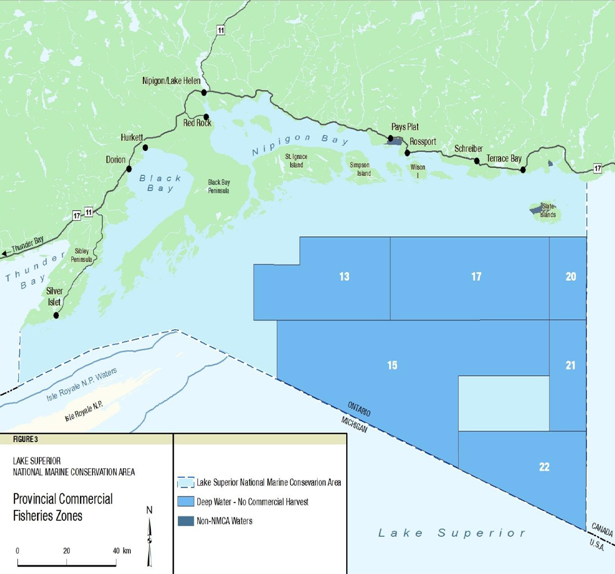
Map - Provincial Commercial Fisheries Zones - Text Version
The zoning plan includes:
- Lake Superior National Marine Conservations Area
- Deep Water - No Commercial Harvest
- Non-NMCA Waters
7.0 Monitoring and Reporting
Parks Canada is accountable to Canadians for the protected heritage places it manages on their behalf. Parks Canada currently reports on the state of individual protected heritage places every five years in a “state of” report that examines First Nations and Métis peoples’ assessment of their relations to the protected heritage place and its management and conditions and trends in natural and cultural resources, public outreach education, partner and stakeholder engagement and visitor experience.
Performance indicators and targets identified in Parks Canada “state of” reports and management plans are, in the case of marine conservation areas, still under development, as is a definition of “visitor” in the context of an NMCA. In lieu of these indicators and targets, the management strategies in this interim management plan are oriented to achieving, in general terms, the expected results articulated in Parks Canada’s Performance Management Framework.
Once a “state of”
reporting model tailored specifically to Parks Canada’s growing network
of NMCAs is in place, a report for the Lake Superior NMCA will be prepared. This report
will assess the state of natural and cultural resources as well as performance expectations
such as the degree of public support for the NMCA and level of enjoyment as a result of a
visitor experience in the area. It will also assess the implementation of actions outlined in
this interim management plan, and will inform the development of the future
management plan. For example, one hypothetical target might be that 90% of visitors
feel a personal connection to the NMCA. Natural resource condition monitoring, Visitor
Information Program visitor surveys, and public outreach education program evaluations
are examples of tools that may be used to assist “state of” reporting for the NMCA.
Monitoring the continuing implementation of this interim management plan and
subsequent management plans will ensure that planned actions support Parks Canada’s
mandate of protection, appreciation and enjoyment.
Looking to the Future—the Management Plan
Experience and information will be gained in the operation and management of the NMCA, during the implementation of this interim management plan and from the contributions of partners and stakeholders, other government bodies and the broader public. This knowledge will support the development of the first Lake Superior NMCA management plan which will replace this interim management plan within five years of the establishment of the NMCA. The future management plan will address how best to integrate the NMCA within the tapestry of adjacent protected areas (listed in Appendix D) with the intent of developing harmonized approaches and actions over time. Working closely with these areas will help to ensure the health and effective long-term protection of both the NMCA and neighboring protected lands.
Through this continued collaboration and the establishment of the management advisory committee as required under the CNMCA Act, the management plan will continue to foster ecologically sustainable use and meaningful visitor experiences, the protection of natural and cultural resources, enhanced ecosystem health, and the increased appreciation of the Lake Superior NMCA.
8.0 Summary of Strategic Environmental Assessment
A strategic environmental assessment (SEA) of the Lake Superior National Marine Conservation Area interim management plan was completed in accordance with the 2010 Cabinet Directive on the Environmental Assessment of Policy, Plan and Program Proposals. This summary includes a discussion of the SEA approach, of potential environmental effects and their contribution to cumulative effects, mitigation, and residual environmental effects. The SEA identifies interactions between actions described in the interim management plan and critical factors which support ecological, cultural and visitor experience values associated with the Parks Canada mandate.
The SEA compares the results of each proposed interim management action against “critical factors.” Critical factors are normally identified in State of the Site Reports (SoSRs), however as the Lake Superior National Marine Conservation Area is still in the process of being established, the SoSR has not been prepared at this time. In the absence of an SoSR, the critical factors and desired outcomes identified in the Lake Superior Lakewide Management Plan (LaMP) have been used to address desired ecological conditions, and are expressed as strategic outcome statements. LaMPs are required under the Great Lakes Water Quality Agreement, (GLWQA) Binational Program partners, and assess the state of the Lake Superior ecosystem, including its ecological impairments, emerging issues and their causes, and gaps in knowledge which require further research and monitoring. Species at Risk are also identified as a critical factor because of Parks Canada’s responsibilities under the Species at Risk Act (2002). Finally, cultural resources and visitor experience are identified as critical factors that reflect Parks Canada’s mandate to protect ecosystems and cultural resources while facilitating meaningful visitor experiences.
Actions contained in the interim management plan are expected to result in primarily positive environmental effects. The completion of comprehensive cultural and natural resource inventories including species at risk, will lead to a greater understanding of the state of those resources which will assist management in enhancing conservation efforts as well as providing material for interpretation and education. These inventories will also assist with identifying meaningful visitor experience opportunities and their locations thereby contributing towards ecologically sustainable use. Positive effects for visitor experience will likely result from the development of a water trail, special cultural heritage trails, providing interpretive and access points and using social science to identify current and future opportunities.
Interim management actions where adverse interactions have been identified are primarily associated with creating new visitor experience opportunities which may introduce new infrastructure (trails, camping, interpretive panels, buildings, etc.) or new activities. Although project or activity details are unspecified at this time, in-water or shoreline works can affect fish habitat, Species at Risk, and wetland structure and function, and can introduce erosion, siltation, invasive or exotic species, and pollutants. Trail and facility development may remove vegetation, fragment ecosystems, introduce invasive species, and affect Species at Risk. The majority of these effects are likely to be eliminated or minimized through appropriate site planning and implementing mitigation measures.
Given the strategic nature of interim management plans, the SEA proposes mitigation measures at a broad level. The design of specific projects or activities should apply environmental codes of good practice in support of achieving ecologically sustainable use. More specific mitigation measures will be developed when conducting individual environmental assessments required under CEAA and Parks Canada policy.
Several actions within the Lake Superior NMCA interim management plan could contribute to cumulative effects, both positively and negatively. Several actions contribute positively towards achieving ecological sustainable use. Adverse cumulative effects are anticipated with infrastructure development.
The interim management actions are likely to support the achievement of desired outcomes. By applying mitigation to specific projects and activities as they are developed, any potential adverse cumulative effects should be minimized or eliminated. The interim management plan has been subject to public, First Nations, and Métis consultation, resulting in improved content. Feedback gained during consultation emphasized the public’s interest in related socio-economic opportunities and the continuing respect for Aboriginal and treaty rights by Parks Canada. Parks Canada also recognizes the need for future engagement of the public, stakeholders and partners as a key element of management planning leading up to the production of the first management plan for the Lake Superior NMCA.
No specific follow-up monitoring requirements are identified in this SEA. Nevertheless, any effectiveness monitoring identified in future SEA and EA analyses will help identify the success of any mitigation measures and identify unforeseen adverse effects so that corrective action can be taken. In addition, implementation of the interim management plan will help complete and consolidate natural and cultural resources inventories and prepare monitoring protocols which will form the basis of a future state of the site report.
Overall, the SEA concludes that the direction proposed in the interim management plan is consistent with Parks Canada environmental and cultural resource management policies and that most of the proposed actions will generate positive environmental effects. With the implementation of future planning and assessment requirements as outlined in the SEA, no adverse residual environmental effects are expected to occur as a result of plan implementation.
Appendix A - Interim Management Advisory Board Recommendations Supplementary to this Interim Management Plan
- That the current members of the Interim Management Advisory Board (post dissolution) serve as members of an informal “Interim Liaison Committee” in order to maintain information exchanges with the LSNMCA Superintendent prior to the establishment of the Management Advisory Committee as described in the CNMCA Act. The Interim Liaison Committee will discuss progress related to the NMCA, raise any issues of concern to the communities and stakeholders, provide input to and receive updates from Parks Canada. Should there be a need to identify additional members to the Interim Liaison Committee in order to maintain information exchanges, nominations will be considered by Parks Canada.
- That the current Board be consulted regarding the form and structure of the future Lake Superior National Marine Conservation Area Management Advisory Committee.
- That the current Board be consulted in the eventual creation of a draft terms of reference for the future Lake Superior National Marine Conservation Area Management Advisory Committee.
- That meaningful consultation and a regular discourse with First Nations, stakeholders and the larger public be maintained as a priority after dissolution of the current Board.
- That the 2001 recommendations of the previous regional committee act as guide to assist with future operational and planning decisions.
- That Parks Canada take steps to maintain and expand working relationships with other natural and cultural heritage management bodies to ensure complimentary management planning practices and priorities are continued into the future.
Appendix B - Interim Management Advisory Board Suggested Interim Research Needs
- Completing a Biological and Socio-cultural Inventory.
“Baseline”
Data- Cultural Heritage
- Potential Degraded Sites
- Shoals and Habitat Structure
- Historical Artifacts
- Shorelines and Aquatic Plants
- Assessing the State and Sustainability of Fisheries Habitat(s).
- Population Inventory
- Management Planning
- Conducting Market Analysis and Completing an Implementation Plan to Address
the Findings.
- Branding and Promotion Trends Analysis
- Education Emphasis
- Connecting Local People
- Determining the Impacts of Human Use.
- Use/Conservation Balance
- Large and Small Impacts
- Baselines of Impacts
- Analyzing Changes to Climate and Water.
- Plants/Hydrology
- Large System Impacts
- Climate Change – Arctic-alpine Plants
- Invasive Species Management.
- Impacts of Exotic Species on Fish
- Wildlife Management
- Invasive Species Control
- Completing an Inventory of Natural/Geological History.
- Glaciation
- Geology
- Plants
Appendix C - Interim Management Plan Development Path
2009
Interim Management Plan Formation and Guiding Management Objectives Developed. (Led by Interim Management Advisory Board in collaboration with Parks Canada)
Management Objectives (to achieve the vision)
- Maintain meaningful community relationships;
- Build an NMCA community;
- Showcase the NMCA;
- Facilitate the Lake Superior Experience;
- Honour the past; and
- Protect and sustain.
2010 - 2011
Management Objectives are Expanded Upon to Produce and Refine Initial Drafts of Management Strategies, Area Concepts and Zoning through:
- The Application of an Integrated Approach to Management Planning;
- Interim Management Advisory Board and Public Feedback; and
- Consultation with First Nations and Métis Communities.
2011 - 2012
Management Strategies, Area Concepts and a Zoning Approach are Finalized in Support of the Vision and 2009 Management Objectives.
Management Strategies:
- Conserving a Sweetwater Sea
- Discovering and Connecting with the “Superior” Legacy
- Enriching Understandings of Past and Present
- Promoting Shared Stewardship
- Reaching out from Local Communities to the World
Area Concepts:
- A Freshwater Ocean – The Water
- Spirits of Wind and Water – The Islands
- On the Edge of an Inland Sea – The Mainland
Zoning:
- Ecologically Sustainable Use Zone
- Protected Area Zone
Appendix D - Other Protected Natural Heritage Areas in the Region (Canadian)
Natural Environment Class Provincial Parks:
Conservation Areas:
Private Nature Reserves:
Reserve:
Land Holding:
Appendix E - Interim Management Advisory Board Vote Results by Member
Members Who Voted for Recommending this Interim Management Plan:
Members Who Voted Against Recommending this Interim Management Plan:
No Vote Received:
Vacant Seats:
Related links
- Date modified :